|
||

|

|
|

|
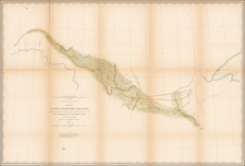
Unrecorded letter sheet map of Cincinnati, based upon an early survey by R.H. Rickey.
This fine small lettersheet map shows the progress of the growth of the City of Cincinnati at an early date.
The present map is one of the earliest obtainable maps of Cincinnati published in the City. The earliest manuscript map of Cincinnati was Israel Ludlow's 1802 Plan of the Town of Cincinnati. The first printed plan of Cincinnati would appear to be Drake's Statistical Plan of Cincinnati . . . (1815), followed by Oliver Farnsworth's Plan of Cincinnati . . . .(1819) . Thereafter, there were several other very rare maps of Cincinnati, published in Cincinnati, including the H.L. Barnum / Doolittle & Munson Topographical Map of Cincinnati in 1831 and Jospeh Gest's City of Cincinnati from Actual Survey in 1838. The Barnum map was re-issued in 1841, along with a small Plan of the City of Cincinnati 1842 by T. Twichel. All of the above are rare to unobtainable.
The present map shows significantly more detail than earlier maps, both north of the Ohio River and in Covington and Newport south of the Ohio River.
R.H. Rickey is identified as the maker of at least 1 other map of Cincinnati, published in 1850 and possibly bound into an early Cincinnati directory.
In 1802, Cincinnati was chartered as a village, and in 1819, it was incorporated as a city. The introduction of steam navigation on the Ohio River in 1811 and the completion of the Miami and Erie Canal helped the city grow to 115,000 citizens by 1850.
![Reize door de binnenlanden van Noord-Amerika, door Jonathan Carver . . . [with map:] Kaart van Capitein Carvers Reize in de binnenlanden van Noord-America in 1766 en 1767](https://storage.googleapis.com/raremaps/img/small/86685.jpg)
![[ Middle British Colonies Map ] Pensilvania Maryland and Virginia](https://storage.googleapis.com/raremaps/img/small/98228.jpg)
![[ Ohio - Seven Ranges ] Plat of the Seven Ranges of Townships being Part of the Territory of the United States N.W. of the River Ohio which by a late act of Congress are directed to be sold . . . 1785](https://storage.googleapis.com/raremaps/img/small/82394.jpg)