This item has been sold, but you can enter your email address to be notified if another example becomes available.


|
||

|

|
|

|
Stock# 32939mb
Description
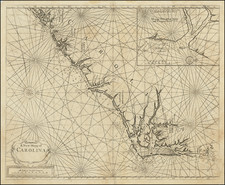
First edition of this rare separately issued Civil War map showing the coastal and inland details of the region from Savannah to Charleston, centered on the entrance to Port Royal.
The map was compiled from information provided by the US Coast Survey. Also located is the Charleston & Savannah Railroad, and a number of rivers, courthouses, forts, roads, towns, creeks, swamps, etc.
While at least one commentator has suggested that the map may have been published for Military use, it would seem more likely that the map was published to inform the public on the Naval Theater in the early part of the Civil War. A later edition includes an inset map of Fort Bearegard.
Condition Description
Minor soiling and several ink stamps showing the acquisition of the map by the Maine Historical Society in 1915.
Reference
Stephenson (CW) #368.1
![[First State?] Rand, McNally & Co's Indexed County Map of North Carolina . . . 1880](https://storage.googleapis.com/raremaps/img/small/87572.jpg)