|
||

|

|
|

|
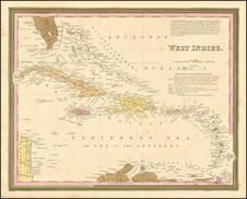
Detailed map of Jamaica, showing counties and parishes, roads, sugar works, and churches in the interior and islands, bays, harbors, shoals, and landmarks along the coastline.
The four corners are filled with a compass rose, scale of miles, explanation key, and the title cartouche, making an attractive composition.
The cultivation of sugar cane and coffee made Jamaica one of the most valuable possessions in the world for more than 150 years. The British colony's slaves, who vastly outnumbered the colonists mounted several major slave conspiracies and uprisings throughout much of the 18th century. This map was issued during a period when the House of Assembly and governor were arguing with the British government over how best to control the situation.