|
||

|

|
|

|
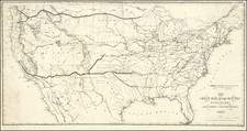
Unique Pike's Peak Gold Rush Pocket Map with Hand Traced Routes To The Gold Regions -- Smoky Hill Route
Important partially hand drawn map of the routes to the Colorado Gold Regions, apparently advocating or favoring the so-called Smoky Hill Route, via Ft. Riley, Kansas, to the gold diggings in 1859.
The present map is one of the most unusual and historically important artifacts which we have offered. The map is comprised of a trimmed fragment of the rare George Elliott broadside map of the United States (see link below), which has been repurposed on the frontier as an overland guide to the Gold Regions of Colorado, with a custom made label and at least 5 different hand drawn routes to the Colorado Gold Regions.
The original broadside map from which this map was taken is George W. Elliott's rare and highly important map, in which only a few surviving examples are known:
Map of the United States Showing By Colors The Area of Freedom and Slavery and the Territories Whose Destiny Is Yet To Be Decided; Exhibiting Also The Missouri Compromise Line and The Routes Colonel Fremont In His Famous Explorations With Important Statistics of the Free and Slave States . . . 1856
A swath of gold coloring has been added to the present map, extending from the Black Hills to the Santa Fe New Mexico area. A north-south road is shown in the gold regions, extending from the Pike's Peak Area through the Denver area and up to approximately Laramie, Wyoming.
The first three routes originate in the area of Ft. Riley, Kansas and include:
- Southerly route through Ft. Mann and Old Ft. Atkinson to the Arkansas River, and on through Bent's Fort.
- Central route along Solomon's Fork to "Prairie Dog", where it joins Fremont's Route of 1843 along the Republican Fork to St. Vrain's Fort.
- Northerly route through Aversville and on to the the Republican Fork, before later joining the Fremont Route of 1843 to St. Vraint's Fort.
The map also shows a route starting in Omaha City and following the Platte River to Ft. Kearney, then tracking the South Platte to St. Vrain's Fort.
Finally, there is a route which appears to originate in Austin, Missouri, east of Old Ft. Kearney, which tracks due west to Ft. Kearney, then along the South Platte to St. Vrain's Fort.
It would appear that this map was offered during the very earliest months of the Pike's Peak Gold Rush. There are two reasons we reach this conclusion. First, the map was almost certainly offered by an early frontier merchant, seeking to outfit gold seekers for the trip west, hence the addition of the words " . . . and Necessary Outfit" to the title of the map. With the first months of 1859, guide books and maps were being actively published throughout the region and further east. As such, this cobbled together map would either reflect a very early creation date (prior to the availability of printed guide books and maps), or the desperation of the local outfitter, who had run out of guidebooks and was forced to create the present "guide map," complete with a printed title. Almost certainly, mutliple copies were created at the time.
Second, the map clearly emphasizes routes departing from the area west of Kansas City, Missouri, with primary emphasis on the so-called Smoky Hill Route. As noted below, this map fell out of favor by the Summer of 1859, due to the treacherous nature of this largely unexplored route.
The Early Routes To Colorado & The Gold Regions.
The present map would seem to be an early frontier artifact of the Colorado Gold Rush, primarily focused on the so-called "Smoky Hill" or Central Route to the Gold Regions. This route would quickly be shown to be the most treacherous and least desirable route, such that by the summer of 1859, it is unlikely that it was being actively advocated.
Following the discovery of gold, three main routes were used in 1859 and 1860. The southern followed the old Santa Fe trail for a large part of the way. Much of this traffic eventually started from Kansas City, Missouri. The northern route followed the old Oregon trail in part, via the Platte river. Some extreme northeastern Kansas towns benefited, but few others. Atchison, Kansas and St. Joseph, Missouri, were the chief starting points, with the latter gaining much of the trade.
Several "central" routes supposedly existed, but by the early spring of 1859 the most popular was the Smoky Hill. This was by way of the Kansas river and its southern fork, the Smoky Hill, with Leavenworth as its principal starting point. The Smoky Hill Trail, followed an ancient Indian trail along the Smoky Hill River. Travelers along the path outfitted in Leavenworth, Kansas City, Abilene, or Salina.
Of all the routes, the Smoky Hill was the most direct. As early as September, 1858, Kansas newspapers were printing statements to this effect. One account asserted that the distance from Wyandotte by the Smoky might be only 500 miles. Another newspaper estimated that the air line distance from Leavenworth was only 555 miles and said there were settlements to within 250 miles of the mines.
Citizens of Wyandotte held a meeting in September, 1858, to push it as an outfitting point. It was argued "that the true route is directly up the Kansas river and Smoky Hill fork." The Lawrence Republican noted on October 7, 1858, that Leavenworth and Kansas City were in contention, with Leavenworth defending the Smoky and Kansas City and Santa Fe. The Republican claimed that the Smoky passed through settled areas farther. A letter to the Junction City Sentinel stated that a man who had returned by way of the Smoky said the distance was shorter, the roads better, the wood, water, and game plentiful, and the settlements farther out.
Besides these newspaper stories, three guide books published early in 1859 stressed the advantages of the Smoky Hill route. The author of one said it was the shortest but cautioned that until it was definitely opened up emigrants should take one of the better established routes. But he stated, "A central route will be opened the coming season," undoubtedly the Smoky Hill route (O.B. Gunn, New Map and Hand-Book of Kansas & the Gold Mines.) A second guide book recommended the Smoky, stating that it followed the banks of streams except for about 130 miles. It advised striking south to meet the Arkansas river in the extreme western portion of the route. (William B. Parsons, The New Gold Mines of Western Kansas... ) A third guide book supported the Smoky for the same reasons ( The Illustrated Miners' Hand-Book and Guide to Pike's Peak... (St. Louis, 1859)).
Praise of the Smoky continued into 1859. The Leavenworth Weekly Times reported on February 12 that the Junction City Sentinel advised emigrants to travel via Leavenworth. This fact was significant, said the Times, because Junction City was in the western portion of the settled part of Kansas and had no interests to serve but the good of the emigrant. What it neglected to mention was that these travelers were also expected to pass through Junction City. In March, a letter in the Times from William Larimer, a correspondent in Denver, stated that four men had recently arrived by way of the Smoky. He reported that they had been very well satisfied with the route. One account noted that in 1843, John C. Fremont had explored the country between the Missouri river and the Rocky Mountains and in his narrative had recommended the Smoky route to the area. "Subsequent explorations have corroborated the view taken by the Great Explorer, and the bulk of the spring emigration will, undoubtedly, select this as their main road."
In Lawrence, the Republican printed a letter March 24,1859, advising emigrants to go directly up the Smoky Hill to its head and then west . The Herald of Freedom Hand-Book and Guide to Pike's Peak agreed, and said Lawrence was the best outfitting point. A letter from the gold fields to the Wyandotte Commercial Gazette stated that several parties had come through by the Smoky Hill. "They report a good supply of wood water and grass." The Junction City Sentinel even became poetic, "Let Hercules do what he may, The Smoky Hill Route MUST have its day."
Within months it was clear that the ideas expressed by these newspapers were incorrect in most instances. As one historian pointed out, in 1858 and 1859 "there was no discernable trail at all after one left Fort Riley.... Added to this lack of knowledge of the route to be taken, those who recommended the Smoky Hill trail had little knowledge of distance." Another writer has commented, "Although it was the most direct, the Smoky was, due to scarcity of water, the hardest and most dangerous of the three great prairie roads from the Big Muddy to the Pike's Peak Gold Region."
A short time later two journalists explained why suffering had occurred on the Smoky Hill. One of them stated, "That route will doubtless turn out as good in the end as either the Northern or Southern. But at the time of the beginning of the Pike's Peak emigration it was but partially explored.... " (Henry Villard, The Past and Present of the Pike's Peak Gold Regions, reprinted from the edition of 1860, with introduction and notes by LeRoy R. Hafen (Princeton, 1932), p. 25.) The other asserted, "Thousands took an unexplored route, up the Smoky Hill river, where grass and water proved woefully scarce and fearful suffering prevailed." (Albert D. Richardson, Beyond the Mississippi ... (Hartford, Conn., 1875), pp. 157, 158.)
Within months, tales of hardship along the Smoky Hill Route doomed it as a primary route westward and its advocates virtually ceased to exist. The unfortunate results of the 1859 spring emigration struck a deathblow to the Smoky Hill route. Very few items appeared in the papers concerning it during the summer and fall of 1859. However, in late September a meeting was held in Manhattan to consider the possibility of surveying and constructing a road from Leavenworth to Denver via Manhattan, Fort Riley, and the Solomon fork. The group appointed a committee to talk to the people of Leavenworth and other towns along the route. This movement never developed further but a similar one concerning the Smoky Hill route did.
In the early part of 1860, discussion of the Smoky Hill route occurred in the Kansas legislature and in some newspapers. Two bills were introduced in the territorial council to establish roads up the Smoky Hill river to some point at the base of the Rocky Mountains. In February, the Rocky Mountain News printed a letter from someone in Denver who said the Platte route was the best, but that most people from the South and Southwest would select the Arkansas (the Santa Fe) route. Only the "fool-hardy and insane" would come up the Smoky Hill, this writer declared. The Kansas Press of Council Grove, located on the Santa Fe route, said of the Smoky Hill route in late February, "we trust no one will be so foolish as to attempt to travel it."
Rarity
This would appear to be a unique survival. We locate no other examples of this specially annotated map or cover title.
![The Theatre of War in North America, with the Roads, and Tables, of the Superficial Contents, Distances, &c.a By and American [with] A Compendious Account of the British Colonies in North-America.](https://storage.googleapis.com/raremaps/img/small/81762.jpg)
![[German Northern Pacific Promotional Tract] Die Nordliche Pacific Eisenbahn; Ihre Route, hulfsquellen, fortschritte & Gefchafte. der neue Nord-Westen und seine grosse Verkehrs-Strasse.](https://storage.googleapis.com/raremaps/img/small/83777.jpg)
![[ English Plantations in North America ] A New Map of the most Considerable Plantations of the English In America Dedicated to His Highness William Duke of Glocester.](https://storage.googleapis.com/raremaps/img/small/98233.jpg)