|
||

|

|
|

|
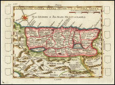
Rare map of the Promised Land, extending from the Red Sea, Mecca and the Nile River on the right side of the map to Damascus and Sidon on the left side, centered on Jerusalem.
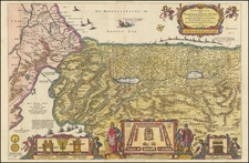
The map shows the Holy Land, the Sinai and the Nile Delta, projected from the East as is often the case but with the Egyptian coast "stretched" to eliminate its western turn. The image is adorned with depictions of villages, towns and fortresses in "bird's-eye perspective" and hundreds of tiny vignettes depicting scenes from the Old and New Testaments. Of further interest are an inset view of the Temple of Solomon, a large inset plan of Jerusalem (its format hearkening back to Visscher's 17th-century plan) and an even larger bird's-eye view of the city, as well as 14 larger vignettes depicting central moments of the Old Testament narrative.
The original prototype for this map seems to have been van Doetechum's 1641 Niewe Caertees das Lants von Beloften ende (Nebenzahl, Holy Land, pp. 120-124, English versions of which were issued by Overton (ca. 1717), Sayer (ca. 1752), Cluer Dicey (ca. 1765), G. Thompson (1795) and others throughout the 18th century. An American edition was pubished by Thomas Duffield's map in Philadelphia in 1828.
All editions of the map are very rare. It is believed that the present example is one of approximately 3 known examples.
![[ Gifted To Cecil B. De Mille by Elmer Bernstein ] (Mortier Bible) Histoire du Vieux et du Nouveau Testament Enrichie de plus de quatre cens Figures En Taille-Douce, &c. [2 vols in 1]](https://storage.googleapis.com/raremaps/img/small/96625.jpg)
![[Historical Time Line Map -- Creation To 100 AD] Tableau de L'Histoire Sainte Depuis La Creation du monde jusqu'a la dispersion du Juifs . . .](https://storage.googleapis.com/raremaps/img/small/82069.jpg)