This item has been sold, but you can enter your email address to be notified if another example becomes available.


|
||

|

|
|

|
Stock# 31083
Description
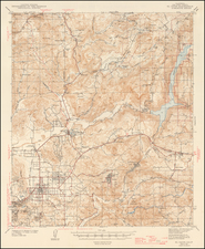
Detailed early map of the San Fernando Valley, published for California Bank.
The map locates the early Electric and Steam railroad lines, towns, post offices and roads in San Fernando Valley, at the beginning of its first major real estate boom. Several proposed street car lines are also shown, along with the Proposed Mullholland Skyline Drive.
Some of the early towns listed have long since been absorbed by other towns, including Girard, Owensmout, Zelzah, Wardlaw, Wahoo, Raymer, Hewitt, and Roscoe.
The map includes some annotations locating the Mears Ranch near Sunland and Tujunga. The map was previously owned by early Los Angeles real estate speculator Walter S. McKee.
Condition Description
Backed with paper at an early date and flattened. Pencil annotations from an early owner.

![[Orange County Ranchos -- Signed by Orange County Surveyor]](https://storage.googleapis.com/raremaps/img/small/92333.jpg)