


|
||

|

|
|

|
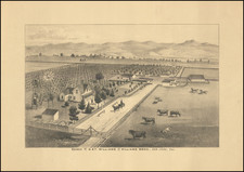
Water For Ontario -- Wine in Guasti
An early map of Guasti in San Bernardino County, California showing the town's water supply at the Cucamonga Wash.
The chart illustrates water pipelines across the city and how they form connections to supply water to other locations. The only color in the chart are these "Hydraulic Grade Lines" in blue which lead to labeled locations like the water tank or the Cucamonga Rancho.
The map identifies two water flumes, a store, wine cellar, engine houses, Richis Tract, "Downey & Childs", and "Cuca House." The map also identifies the "Zanta," a reference to a zanja, the open ditch water distribution system used in early Southern California the early California Rancho period.
"Downey & Childs" likely refers to California Governor John Downey and Ozro Childs, an early Los Angeles Horticulturalist.
Further west, the map shows the Cucamonga Road and Riverside Road, just north of the Cucamonga Wash.
Chart states it was done in 1877, however, the addition of several manuscript annotations indicates a later usage/revision perhaps around 1918. A note in the far right illustrates a section where a piece of connecting pipe was placed in 1903 while also stating as of 1918 there was no connection further along the pipeline. Various portions of the map are crossed out (such as the title) or with additional text (such as the notes of inclusion of the town name Guasti in the title).
Guasti was known for wine production and viticulture production continues to be a major industry in the area. Guasti was annexed by Ontario, CA in the mid-20th century.

![[Monterey] Plan De La Baie De Monterey Situee Dans La Californie Septentrionale . . .](https://storage.googleapis.com/raremaps/img/small/99008.jpg)
![[Southern California Views] Delightful Southern California, The Land of Sunshine and Bloom](https://storage.googleapis.com/raremaps/img/small/74862.jpg)