


|
||

|

|
|

|
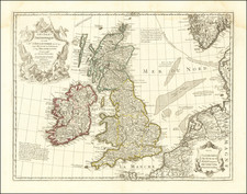
First proof state of De Wit's very rare map of the British Isles.
De Wit's map is based on Jansson's map of the British Isles. This examples is the first of two proof states with the cartouche blank, as well as certain topographical features and place names lacking.
Shirley lists, but does not illustrate, the map in Early Printed Maps of the British Isles (#663) and again in Printed Maps of the British Isles. While Shirley suggests that the map is c1650, we believe it is closer to 1658 or 1659.
There were 3 subsequent states of the map. In the second state, a partial proof state, the cartouche is half-completed but undated. States 3 and 4 are complete, and each is dated 1659 in the cartouche.
De Wit (1629 ca.-1706) was a mapmaker and mapseller who was born in Gouda but who worked and died in Amsterdam. He moved to the city in 1648, where he opened a printing operation under the name of The Three Crabs; later, he changed the name of his shop to The White Chart. From the 1660s onward, he published atlases with a variety of maps; he is best known for these atlases and his Dutch town maps. After Frederik’s death in 1706, his wife Maria ran the shop for four years before selling it. Their son, Franciscus, was a stockfish merchant and had no interest in the map shop. At the auction to liquidate the de Wit stock, most of the plates went to Pieter Mortier, whose firm eventually became Covens & Mortier, one of the biggest cartography houses of the eighteenth century.
![[English Channel] De Cust van Vlaenderen en Engelandt van Oostende tot deur de Hoofden](https://storage.googleapis.com/raremaps/img/small/75243.jpg)
![[ Atlas of England & Wales ] Geographiae Blauianae Volumen Quintum, quo Anglia, quae est Europae liber undecimus, continentur](https://storage.googleapis.com/raremaps/img/small/99196.jpg)
![[Ascension Island] The True Description of the Island of Ascention lyeing under 8 degrees on ye South syde of ye Equinoctiall lyne.](https://storage.googleapis.com/raremaps/img/small/78964.jpg)