|
||

|

|
|

|
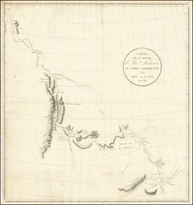
Detailed map of a portion of the Yenisey River in Siberia.
The map shows the area around Mangazeyka and
Mangazeya was a Northwest Siberian trans-Ural trade colony and later city in the 16-17th centuries. Founded in 1600, it was situated on the Taz River, between the lower courses of the Ob and Yenisei Rivers flowing into the Arctic Ocean.
Russian settlers of the White Sea coasts of Russia (pomors) had found a route along the Arctic coast to Arkhangelsk to trade with Norwegian, English and Dutch merchants. Mangazeya was used to accumulate furs and ivory (walrus tusks) around the year to be shipped out during the short Northern summer.
This trade route was forbidden in 1619 under the penalty of death, for two reasons: the state was unable to collect on it, and there was a fear of English trading penetration into Siberia. The city survived another 50 years, but eventually Mangazeya was abandoned. Following the catastrophic fire of 1662, the remaining population was evacuated to Turukhansk at the junction of the Yenisei with the Lower Tunguska, which was known as New Mangazeya until the 1780s.
The Yenisey River is the largest river system flowing to the Arctic Ocean. It is the central of the three great Siberian rivers that flow into the Arctic Ocean (the other two being the Ob River and the Lena River). Rising in Mongolia, it follows a northerly course to the Yenisei Gulf in the Kara Sea, draining a large part of central Siberia, the longest stream following the Yenisei-Angara-Selenga-Ider river system.
Jacques-Nicolas Bellin (1703-1772) was among the most important mapmakers of the eighteenth century. In 1721, at only the age of 18, he was appointed Hydrographer to the French Navy. In August 1741, he became the first Ingénieur de la Marine of the Dépôt des cartes et plans de la Marine (the French Hydrographic Office) and was named Official Hydrographer of the French King.
During his term as Official Hydrographer, the Dépôt was the one of the most active centers for the production of sea charts and maps in Europe. Their output included a folio-format sea atlas of France, the Neptune Francois. He also produced a number of sea atlases of the world, including the Atlas Maritime and the Hydrographie Francaise. These gained fame and distinction all over Europe and were republished throughout the eighteenth and even in the nineteenth century.
Bellin also produced smaller format maps such as the 1764 Petit Atlas Maritime, containing 580 finely-detailed charts. He also contributed a number of maps for the 15-volume Histoire Generale des Voyages of Antoine François Prévost.
Bellin set a very high standard of workmanship and accuracy, cementing France's leading role in European cartography and geography during this period. Many of his maps were copied by other mapmakers across the continent.
![Carte des nouvelles decouvertes dresseee par Phil. Buache… [with] Extrait d'une Carte Japonoise de l'Univers apportee en Europe par Kaempfer . . . [Bay of the West]](https://storage.googleapis.com/raremaps/img/small/84038.jpg)