


|
||

|

|
|

|
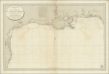
Scarce French edition of the Direccion de Hidrographia's Carta Particular…de las Costas Setentrionales del Seno Mexicano..., first published in Madrid in 1807.
In 1783, Bernardo de Galvez, the interim governor of Spanish Louisiana commisioned Jose Antonio de Evia to explore and map the northern coast of the Gulf of Mexico from West Florida to Tampico. Evia explored the coasts and bays of Florida, Alabama, Mississippi, Louisiana, Texas and Mexico, completing his survey in September 1786. Along the way, de Evia surveyed San Bernardo Bay and named it for his patron Galvez, who had by then been named Viceroy of Mexico.
Don Juan Francisco de Langara y Harte, the Spanish Secretary of the Navy, employed Evia's work to publish a general chart of the region, Carta Esferica que comprehende las costas del Seno Mexicano in 1799, which became the most important advance in the cartography of the Gulf Coast for many years. In 1807, a larger scale chart, the Carta Particular…, covering the region between the Rio Grande and the Mississippi was issued. This map represented a large advance over the Jefferys map (Martin & Martin Pl. 21).
Re-issues of the Carta Particular . . . were done in France, Spain and Mexico for the next several decades. This 1826 French example retains most of the Spanish nomenclature. A nice example of this scarce large format map of the Texas Coast. An essential map for Texas collectors, which has become rare on the market.
The Dépôt de la Marine, known more formally as the Dépôt des cartes et plans de la Marine, was the central charting institution of France. The centralization of hydrography in France began in earnest when Jean-Baptiste Colbert became First Minister of France in 1661. Under his watch, the first Royal School of Hydrography began operating, as did the first survey of France’s coasts (1670-1689). In 1680, Colbert consolidated various collections of charts and memoirs into a single assemblage, forming the core of sources for what would become the Dépôt.
The Dépôt itself began as the central deposit of charts for the French Navy. In 1720, the Navy consolidated its collection with those government materials covering the colonies, creating a single large repository of navigation. By 1737, the Dépôt was creating its own original charts and, from 1750, they participated in scientific expeditions to determine the accurate calculation of longitude.
In 1773, the Dépôt received a monopoly over the composition, production, and distribution of navigational materials, solidifying their place as the main producer of geographic knowledge in France. Dépôt-approved charts were distributed to official warehouses in port cities and sold by authorized merchants. The charts were of the highest quality, as many of France’s premier mapmakers worked at the Dépôt in the eighteenth century, including Philippe Bauche, Jacques-Nicolas Bellin, Rigobert Bonne, Jean Nicolas Buache, and Charles-François Beautemps-Beaupré.
The Dépôt continued to operate until 1886, when it became the Naval Hydrographic Service. In 1971, it changed names again, this time to the Naval and Oceanographic Service (SHOM). Although its name has changed, its purpose is largely the same, to provide high quality cartographic and scientific information to the France’s Navy and merchant marine.

![La Parte Occidentale Dell'Antico, E Nuovo Messico Con Florida E La Bassa Luigiana…. 1798 [California & The Southwest!]](https://storage.googleapis.com/raremaps/img/small/95816.jpg)
![[Restricted] New Orleans (0-6)](https://storage.googleapis.com/raremaps/img/small/68648.jpg)