


|
||

|

|
|

|
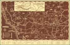
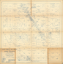
Fine early map of Dana Point, almost certainly the first printed map to show the town.
The present map, which locates a number of ambitious future improvements, including a hotel, country club, polo field, ridng ring stables, schools, airport, reservoir, aeroplane beacon, observation house and bridge, would appear to be the earliest map of Dana Point. The map references Dana's Stillwater Bay, a reference to Richard Henry Dana's name for the modern Capistano Bay. Woodruff would prepare a tract map in 1929 (1 recorded example-Yale), so our assumption is that since this map does not show a residential subdivision or street names, it likely pre-dates the tract map.
Dana Point was named for Richard Henry Dana, Jr., author of "Two Years Before The Mast". Dana referred to Stillwater Bay as the most Romantic spot on the Coast. Dana was traveling aboard the brig Pilgrim, which at the time had to travel to California via Cape Horn and the Straits of Magellan.
In 1923, Los Angeles Times publisher Harry Chandler and General M.H. Sherman, Director of the Pacific Electric Railway Company, created a major real estate group to develop what is known today as the Hollywood Hills, Sidney H. Woodruff, already a prominent Los Angeles homebuilder, was hired to lead the project. In 1926, Woodruff, Chandler, and Sherman created the Dana Point Syndicate. They invited other heavy hitters, company presidents, movie producers, and real estate investors, to join them in purchasing 1,388 acres (5.6 km2) of land, some of which includes the "Headlands" of today. Promising tree-lined, paved streets, electricity, telephones, sidewalks, water mains, storm drains, sewers, and other amenities, Woodruff built 35 homes and a number of commercial buildings.
Most of these "Woodruff" houses are concentrated in a Dana Point's historic core, also called Lantern Village (currently about 12,000 residents). The streets are named after the different colored lanterns, street of the Violet Lantern, Blue Lantern, etc. (colored lanterns were used by ships 200 years ago to advertise their fares when pulled into the Dana Point natural harbor). His crowning structure was to be the Dana Point Inn, a Mediterranean-like resort hotel. After a celebratory groundbreaking in 1930, a three-story foundation was poured and a 135-foot (41 m) elevator shaft was dug. Unfortunately, the Depression caused construction to halt. Although Woodruff continuously sought financial support through the years, this project was abandoned in 1939. Subsequently, he sold the remaining holdings of the Dana Point Syndicate. Thirty-four of the original Woodruff residences are still occupied.
No other example of the map located. This example is from the papers of S.H. Woodruff.
![[Drake's Bay to Fort Bragg] Bodega Head to Abalone Point From The Latest United States Government Charts . . .](https://storage.googleapis.com/raremaps/img/small/73078.jpg)