|
||

|

|
|

|
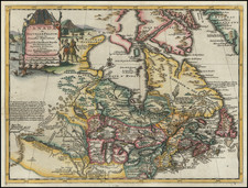
A section of the Italian edition of Mitchell's seminal map of North America, bounded by Lakes Huron & Oswego and Ohio in the west and extending to Long Island, Lake Champlain etc. in the east. The map was part of Zatta's Atlante Novissimo, one of the great Italian maps of North America in the late 18th Century. The map includes the same details as Mitchell's map, including roads, forts and settlements throughout the region, and details and other minute details. Many annotations. A nice example of this sectional derivative of Mitchell's seminal map.
Antonio Zatta (fl. 1757-1797) was a prominent Italian editor, cartographer, and publisher. Little is known about his life beyond his many surviving published works. It is possible that he was born as early as 1722 and lived as late as 1804. He lived in Venice and his work flourished between 1757 and 1797. He is best known for his atlas, Atlante Novissimo (1779-1785), and for his prolific output of prints and books that were both precisely made and aesthetically pleasing. Zatta clearly had a large network from which to draw information; this is how he was able to publish the first glimpse of the islands visited by Captain Cook in the Atlante Novissimo. Zatta also published books of plays and architecture.
![Colton's Map of the United States The Canadas &c. Showing the Railroads, Canals, & Stage Roads With Distances From Place to Place…1856 [Pocket Map]](https://storage.googleapis.com/raremaps/img/small/85342.jpg)
![Carte Du Canada ou de la Nouvelle France et des Decouvertes qui y ont ete faites . . . [Map of Canada or New France and the Discoveries Made Therein . . .]](https://storage.googleapis.com/raremaps/img/small/94450.jpg)