|
||

|

|
|

|
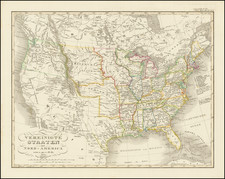
Rare separately issued map, showing the Southern States from the east coast, north as far as the northern borders of Missouri and New Jersey, west to the western borders of Missouri and Louisiana.
Scattered throughout the Map are bust portraits of Union Generals and Navy Admirals as they appeared in the early months of the War. The portraits are positioned relative to the areas of the country when that General was serving in mid to late 1861. General Winfield Scott is depicted at the lower right hand corner as the commanding General of the Union Army and he is surrounded by generals on his staff. General Ulysses S. Grant is depicted with a very long beard and stationed in the department of the West.
This Map was among the very first of its type published after the War began. Few families during the Civil War were without someone involved in the Military, explaining the eventual high demand for maps that provided accurate and up-to-date geographical information. These maps were also used to bolster the patriotic impulses of the populace by keeping them imaginatively involved in the war . By 1862 publishers in New York, Philadelphia, Washington and Boston took advantage of this burgeoning market, increasing map production to unprecedented levels. The Civil War marked the advent of American commercial mapmaking.
This very early example of the Civil War time Map is characteristic of the maps produced during the War in the North. Bold, patriotic colors (here faded), original pictorial and text arrangements, illustrative data and decorative titles were attractive and novel methods used by publishers to boost sales.
One copy located: British Museum.
![La Florida [with] Guastecan [with] Peruviae Avriferae Regionis Typus](https://storage.googleapis.com/raremaps/img/small/89451.jpg)