


|
||

|

|
|

|
The Map Chosen For The Cover Art For Guthhorn's Book On American Sea Charts
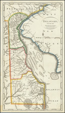
One of the most decorative and sought after 19th Century charts of the Chesapeake, from one of America's first great commercial map makers, and the only sea chart published by Lucas. The chart appears on the cover of Guthorn's United States Coastal Charts, 1783-1861.
Fielding Lucas, a prominent 19th-century cartographer, is acclaimed for his remarkable sea chart of the Chesapeake and Delaware Bays. This piece, celebrated for its detailed accuracy and aesthetic charm, is one of the most coveted 19th-century charts of Chesapeake Bay.
The chart prominently features inland navigation, stretching as far upstream as Philadelphia, Port Deposit, Baltimore, Washington, and along significant lengths of the Rappahannock, York and James Rivers. Soundings permeate along the eastern shore, extending into the lower Chester River, Eastern Bay, the mouth of the Choptank, and Tangier Sound. With remarkable clarity, the entrances to both major bays demonstrate significant shoals, and the bays on the Atlantic side of the peninsula are sketched.
Four coastal profile views, as well as tide tables for both bays, further enrich the chart's detail. In a testament to its authenticity, the chart also features the pasted label of Hagger & Brother, leading providers of Nautical & Scientific Instruments in Baltimore in the early 1850s.
This chart, noted by the Maryland Historical Society as a pinnacle of Lucas' meticulous craftsmanship, includes soundings, locations of shoals, light boats, and lighthouses, with brief descriptions of the lights on different boats. The chart also showcases "Tide Tables" for the Chesapeake and Delaware Bays and a series of views of Cape Henry, Smiths Point Light House, Windmill Point and Cape Henlopen. These views, initially appearing on Anthony De Mayne's "Survey of the Chesapeake" of 1814, lend significant detail to the chart.
In the mid-19th Century, inland navigation was a critical component of American commerce. With the completion of the Chesapeake and Delaware Canal in 1829, depicted in the 1832 edition of the chart, commercial routes were revolutionized. The detailed representation of shoals was a significant advancement over many charts of the period, contributing to safer and more efficient maritime navigation.
Lucas' pioneering use of color was a remarkable innovation, not adopted by subsequent US. Coast Survey agencies until the 20th Century. Lucas issued the first edition of the chart in 1829, and he regularly updated it until 1859. It was a noteworthy innovation that showcased his vision and commitment to accuracy. A testament to its practical use, the chart is backed on linen, highlighting its history as a working chart.
As noted by the Maryland State Archives in its description of the 1832 edition of the chart (Huntingfield Map Collection, S1832); "Lucas' primary innovation in this chart was the use of color, not adopted by the successor agencies of the US. Coast Survey until the 20th Century. . . . This was one of the first charts to depict the Chesapeake and Delaware Canal, completed in 1829. . . The configuation of the shoals is much more detailed than in many charts of the period." Lucas periodically updated the map between 1832 and 1859.
Fielding Lucas, Jr. (1781-1854) was a prominent American cartographer, engraver, artist, and public figure during the first half of the 19th century.
Lucas was born in Fredericksburg, Virginia and moved to Philadelphia as a teenager, before settling in Baltimore. There he launched a successful cartographic career. Lucas's first atlas was announced in early- to mid-1812, with production taking place between September 1812 and December of 1813, by which point the engravings were complete. Bound copies of the atlas -- A new and elegant general atlas: Containing maps of each of the United States -- were available early in the next year, beating Carey to market by about two months. Lucas later published A General Atlas Containing Distinct Maps Of all the known Countries in the World in the early 1820s.
![[ New York and New Jersey ] Mappa Geographica Provinciae Novae Eboraci ab Anglis New-York… Claudii Josephi Sauthier cui Accedit Nova Jersey ex topgraphicis . . . 1778](https://storage.googleapis.com/raremaps/img/small/103550.jpg)