


|
||

|

|
|

|
An English Rarity
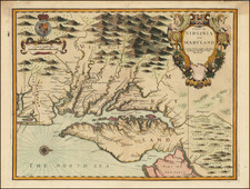
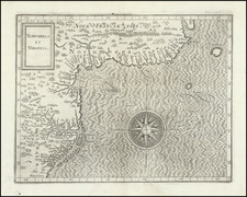
First state of Thornton's sea chart of the Canadian, Northeast and Mid-Atlantic coast, the most up-to-date sea chart of the period.
Prior to 1685, John Thornton's former partner William Fisher had entered into a partnership with Richard Mount. As part of the dissolution of the Thornton & Fisher association, a map covering a similar region passed into the hands of the Fisher & Mount partnership, fortuitously requiring Thornton to issue a new edition of the map.
While the two maps bear some similarity, Thornton's 1685 chart includes two significant changes from the earlier chart. First, in his chart of 1685, Thornton's geographical focus shifts considerably to the south and west, reaching south to include all of the Virginia coastline and part of the Carolina coastline, as far south as Cape Hattarass (Hatteras), and also allowing for significantly more information on the inland waterways of the Chesapeake and Albemarle Sound.
The second noteworthy difference is the additional detail and source material employed by Thornton. Thornton's chart includes significantly more detail, as well as information not previously shown on any other printed map, including the first appearance of Portland, Dover, Buzzard's Bay and Stoneing [Stonington], on a printed map. Burden notes:
The main amendment is the inclusion of the new colony of PENNSYLVANIA. The site of Philadelphia City is illustrated next to the 'Chuylkill River', as are many new toponyms on the Delaware River . . . The south-eastern region of New England is particularly altered with many new soundings and sand bars displayed . . . The charting of New York Harbor bears a resemblance to the cartography of Phillip Wells, who issued a manuscript chart of New York Harbor circa 1683.
Burden goes on to note that the long river flowing southwest out of Le Grand Sault St. Louis "reflects Thornton's knowledge of the voyage of Louis Jolliet and Jacques Marquet down the Mississippi River in 1673" and first reported in 1681. The waterway first delineated by Sir Robert Dudley's Cart particolare della Terra Nuova is shown, derived from John Daniell's manuscript map of 1637.
Rarity
Thornton's 1685 chart is of great rarity A 2008 catalog entry by Martayan Lan stated that there is no record of this chart having been catalogued in the last 25 years or otherwise on the market.
![[ Ottawa ] City of Ottawa Canada West](https://storage.googleapis.com/raremaps/img/small/74782.jpg)