|
||

|

|
|

|
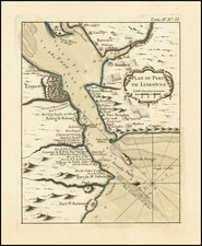
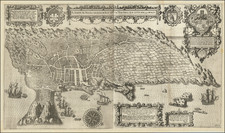
Decorative pair of plans showing the fortified towns of Elvas and Evora.
Elvas is a fortified hilltop town on the Spanish border east of Lisbon. The Portuguese too the city fromthe Moors in 1226 and it was captured by Spain in 1580. The fortifications date mostly from the 17th century and there is a 16th-century aqueduct.
Evora is the capital of the province of Alentejo, east of Lisbon, It was captured by the Romans in 80 BC and has a Roman aqueduct and temple of Diana, the goddess of hunting. There is also a 13th-century Gothic cathedral. From the 14th to the 16th centuries Evora was the residence of the Kings of Portugal.
Nicholas de Fer (1646-1720) was the son of a map seller, Antoine de Fer, and grew to be one of the most well-known mapmakers in France in the seventeenth century. He was apprenticed at twelve years old to Louis Spirinx, an engraver. When his father died in 1673, Nicholas helped his mother run the business until 1687, when he became the sole proprietor.
His earliest known work is a map of the Canal of Languedoc in 1669, while some of his earliest engravings are in the revised edition of Methode pour Apprendre Facilement la Geographie (1685). In 1697, he published his first world atlas. Perhaps his most famous map is his wall map of America, published in 1698, with its celebrated beaver scene (engraved by Hendrick van Loon, designed by Nicolas Guerard). After his death in 1720, the business passed to his sons-in-law, Guillaume Danet and Jacques-Francois Benard.
![[ Tracking The Armies of Bonaparte and the English During The Peninsular Campaign ] New Map of Spain and Portugal By E. Mentelle, Member of Institute of Science at Paris, and P. G. Chanlaire, One of the Authors of the National Atlas](https://storage.googleapis.com/raremaps/img/small/99148.jpg)