


|
||

|

|
|

|
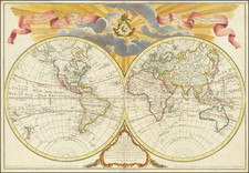
Interesting double hemisphere map of the World, revised by Dezauche to include the discoveries of Captain James Cook on his three voyages of exploration in the Pacific.
Among the most noteworth corrections are the additions of the Cook routes (which are named), the inclusion of Hawaii, reformation of Australia to include the East Coast, more accurate delineation of New Zealand and the retention of the Northwest Passage, although acknowledging that there are ice flows which block the passage above Alaska.
The United States (Etats Unis) is named. The NW Coast of America and Alaska are still very poorly understood and there is no sign of Antarctica.
Jean-Claude Dezauche (fl. 1780-1838) was a French map publisher. Initially, his work focused on engraving music, but he later turned primarily to cartography. His is best known for editing and reissuing the maps of Guilluame De L’Isle and Philippe Buache, two of the most skilled mapmakers of the eighteenth century. He acquired the plates of these two men’s work in 1780 from Buache’s heir, Jean-Nicolas Buache. Dezauche's business received a further boon when he received a privilege to sell the charts of the Dépôt de la Marine. His business was carried on by his son, Jean-Andre Dezauche.

![[Grotto of Tethys -- Versailles] Le Soleil qui se couche dans la mer / Le Globe de la Terre, divise en six parties.](https://storage.googleapis.com/raremaps/img/small/79606.jpg)