|
||

|

|
|

|
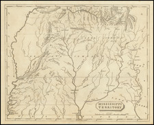
Rare plan of Mobile Bar, as surveyed by Bernard Romans, during the period of English control of East and West Florida, following the French & Indian War.
The map shows extensive soundings, Isle Dauphin, Mobile Point, Pelican Island, Old Harbor, Sandy Harbor, Bay Andry, Guillaret Island, Herron Pass, along with Anchorages and several notes.
The map is based a survey conducted by Bernard Romans.
Bernard Romans was a Dutch-born American navigator, surveyor, cartographer, naturalist, engineer, soldier, promoter and writer. His best known work, A Concise Natural History of East and West Florida, published in 1775, is a valuable source of information about the Floridas during the period of British control. His maps and charts are considered better than any produced before, and often for many years after, their publication.
In 1766-67, Romans commanded the sloop Mary. On his first voyage, the ship ran aground on the Dry Tortugas, but he was able to get the ship off and reach port. On his second voyage, the ship was lost near Cape Florida (Key Biscayne). Having lost much of his personal wealth with the wreck of the Mary, Romans turned to surveying. He became the deputy surveyor of Georgia and also accepted private commissions to survey land grants in East Florida, which had come under British control at the end of the French and Indian War.
In 1768, Romans became principal deputy surveyor for the Southern District (the British Colonies of Virginia, North Carolina, South Carolina, Georgia, East Florida and West Florida). Starting in 1769, Romans surveyed the coastal waters of East Florida. Later that year, his boat sank in the Manatee River near Tampa Bay. Romans walked overland from there to St. Augustine. Well aware of the historical significance of where he walked, he later wrote that he had been "on Ferdinando Soto's tract". He outfitted another boat at his own expense, and resumed surveying the coast in September 1770. He reached Pensacola, Florida in August 1771, having recorded depth soundings, good harbors and sources of fresh water, and drafted coastal charts, for much of the East Florida coast.
Upon reaching Pensacola, Romans was hired to survey the western part of West Florida and the lands of the Choctaws and Chickasaws. The survey was undertaken during tumultuous times, as the Choctaws and the Creeks were at war. Rumors even reached Mobile that Romans and his party had been killed by Creeks. Roman's survey work in West Florida continued into 1772.
Romans' was decidely pro-American in his sympathies. He appeared before the Boston Marine Society on December 1, 1773, and was in the city when the Boston Tea Party occurred. In early April 1775, Romans was appointed a captain by the Connecticut Committee of Safety, with a charge to take Fort Ticonderoga and nearby British fortifications. While Benedict Arnold and Nathanael Greene took command of the large body of troops headed for Fort Ticonderoga, Romans' company was sent to capture Fort George on Lake George, a neglected post which surrendered without a fight. Romans went on to Ticonderoga, where he helped assess the ammunition that had been captured. Benedict Arnold reported favorably on Romans as an engineer after this service.
Romans soon returned to Connecticut. It is not known if Romans was present at the Battle of Bunker Hill, but he published an illustration of it, An Exact View of the Late Battle at Charlestown, June 17, 1775. Romans also published a map of the area around Boston, The Seat of Civil War in America, and dedicated it to John Hancock. Romans' earlier work was also used by the British in their maps, particularly in A General Map of the Southern British Colonies, which was included in the American Military Pocket Atlas, intended for the use of mounted British officers.
In New York, James Rivington had proved to be too neutral in his coverage of the growing conflict between the colonies and Britain, and, in November 1775, a mob of patriots destroyed his print shop. The second volume of Romans' book was in production at the time and was lost.
Later, in 1775, the Continental Congress recommended Romans to the New York Commissioners for Fortifications in the Highlands to oversee the construction of a fort at Martelaer's Rock, across the Hudson River from West Point. Romans set to work surveying the river and designing fortifications. When the commissioners inspected the site, they were unhappy both with Romans' plans and with the site, which was exposed to the superior positions available across the river on West Point. Romans went to New York City and presented his plans to the Committee of Safety without mentioning the doubts expressed by the Commissioners. the Committee of Safety forwarded Romans' plan and expenses to the Continental Congress and, according to Romans, promised him that he would be appointed principal engineer for New York with the rank and pay of a Colonel.
A struggle ensued for control of the project between Romans and the Commissioners for Fortifications in the Highlands. Romans proceeded with much of the work, but eventually went to Philadelphia to report and seek support. While Romans appeared to win approval from the Congress, it was generally recognized that his work had not been very successful. In George Washington's words, Romans's fortifications were "very neat" and "very picturesque" but "upon the whole, Mr. Romans has displayed his genius at a very great expense and to very little publick advantage."
Romans was next given a commission of captain of the First Pennsylvania Company of Artillery, which soon joined the campaign against Quebec. After the Americans were defeated in Quebec, Romans's company was reassigned, in July 1776, to Fort Ticonderoga. Shortly after, General Horatio Gates sent Romans to investigate the preparations being made under the direction of Major General Philip Schuyler to defend Lake Champlain against the expected British invasion. Romans was shocked by the sight of the vessels being prepared for the lake fleet, but was unable to do anything. This fleet was soon defeated at the Battle of Valcour Island. Fortunately for the Americans, the battle had also been costly for the British, and they delayed their invasion southwards.
In November 1776, the Pennsylvania Council of Safety appointed Romans Engineer and ordered that he be furnished with the means to conduct an experiment in "destroying distant objects by fire." Unfortunately, there is no further record of this experiment. Romans also continued to produce maps, including two of Connecticut, one centered on Philadelphia, including most of New Jersey and Delaware, and portions of Maryland and Pennsylvania, showing the location of the Grand American Winter Camp 1778 at Valley Forge, and a map of the Northern Department of North America (this was the first map to use the name Vermont).
Romans resigned his commission on June 1, 1778. He continued working on a history of the oppression of the Netherlands by the British. By the end of 1778, he had finished the two-volume Annals of the Troubles in the Netherlands, and the first volume was in the bookstores in January 1779. The second volume did not appear until 1782.
Romans joined the Southern Campaign in 1780. It is not clear what Romans's assignment was to be, but an application for a pension filed by Elizabeth Romans in 1848 states that Romans "was ordered to go to the State of South Carolina, there to join the Southern Army". The ship on which Romans was traveling from New London, Connecticut to Charleston, South Carolina was captured by the Royal Navy. Romans was held prisoner until the war ended. He died aboard ship while returning home.
Sayer & Bennett refers to the partnership of Robert Sayer (ca. 1724-1794) and John Bennett (fl. 1760-d.1787), which lasted between 1774 and 1783. Bennett had been Sayer’s apprentice. The pair specialized in American atlases, based on the work of Thomas Jefferys, who plates had been acquired by Sayer when Jefferys went bankrupt in 1766. They also began publishing navigational charts in the 1780s and quickly became the largest supplier of British charts in the trade. However, in 1783 Bennett lost control of his mental faculties and the partnership dissolved as a result. Sayer’s business was later passed to his employees, Robert Laurie and James Whittle.