|
||

|

|
|

|
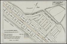
Detailed early map of Redlands, California, at the beginning of the 20th Century.
The map extends from the Santa Ana River Wash and San Bernardino Avenue in the North to San Timoteo Canyon, and from Canyon Crest Park and San Mateo in the west to Wabash Street in the East and the Country Club.
The Country Club, Prospect Park, Reservoir, Souther California Railway, and other details are shown. Wabash Avenue (running north and south in a straight line) is a a curious feature, as the modern street is located in the hills and follows a serpentine pattern from the 10 Freeway Southward, to the top of the hill, where it crosses Sunset (and then passes within 100 yards of my parents home!). Sunset is "Sunset Drive or New Redlands Drive." There is very little development south of Crescent and south of Sunset. Elizabeth and Garden merge to form Live Oak Canyon Road, running south.
A fascinating map of the town.
![The Mother Lode of California [Guide to the Mother Lode Mariposa to Downieville]](https://storage.googleapis.com/raremaps/img/small/97535.jpg)
![[ Sonoma County ] Map of Sonoma County California Showing New Boundary Lines of County and Townships, Private Claims and Ranches, Government Townships and Section Lines, Rail Roads and Public Roads Water Works Cities Towns School Districts, etc. Carefully Compiled From The Latest Authorities By R.A. Thompson, County Clerk . . . 1884](https://storage.googleapis.com/raremaps/img/small/99877.jpg)