|
||

|

|
|

|
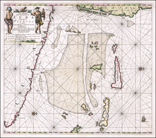
Scarce harbor plan, showing Bahia Honda, on the north coast of Cuba.
The map includes soundings, anchorages, sand bars, fishing areas and a fresh water well on Green Island. The Bay was the location of an American Naval Base under the Platt Amendment, but was abandoned in favor of an expansion of Guantanimo Bay.
Sayer & Bennett refers to the partnership of Robert Sayer (ca. 1724-1794) and John Bennett (fl. 1760-d.1787), which lasted between 1774 and 1783. Bennett had been Sayer’s apprentice. The pair specialized in American atlases, based on the work of Thomas Jefferys, who plates had been acquired by Sayer when Jefferys went bankrupt in 1766. They also began publishing navigational charts in the 1780s and quickly became the largest supplier of British charts in the trade. However, in 1783 Bennett lost control of his mental faculties and the partnership dissolved as a result. Sayer’s business was later passed to his employees, Robert Laurie and James Whittle.

![[Florida Keys, Cuba, Bahamas, Cayman Islands] The Island of Cuba with part of the Bahama Banks & the Martyrs . . .](https://storage.googleapis.com/raremaps/img/small/85166.jpg)