|
||

|

|
|

|
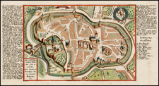
Detailed battle plan, showing the Battle of Friedlingen, fought near Basle in in October 1702.
The Battle of Friedlingen was fought in 1702 between France and the Holy Roman Empire. The Imperial forces were led by Louis William, Margrave of Baden-Baden, while the French were led by Claude Louis Hector de Villars. The French were victorious. The French were seeking to expand their influence on the eastern bank of the river Rhine. In the autumn of 1702, Villars received orders from Louis XIV to attack Swabia. The French forces needed to join their Bavarian allies and defeat the Imperial troops that stood between them.
The French crossed the Rhine at Weil am Rhein, just north of Basle October 14, 1702. Villars attacked the Imperial army at Friedlingen. The future field marshal Louis William entrenched his army and managed to hold the French for some time. He then retreated to the North.
Nicholas de Fer (1646-1720) was the son of a map seller, Antoine de Fer, and grew to be one of the most well-known mapmakers in France in the seventeenth century. He was apprenticed at twelve years old to Louis Spirinx, an engraver. When his father died in 1673, Nicholas helped his mother run the business until 1687, when he became the sole proprietor.
His earliest known work is a map of the Canal of Languedoc in 1669, while some of his earliest engravings are in the revised edition of Methode pour Apprendre Facilement la Geographie (1685). In 1697, he published his first world atlas. Perhaps his most famous map is his wall map of America, published in 1698, with its celebrated beaver scene (engraved by Hendrick van Loon, designed by Nicolas Guerard). After his death in 1720, the business passed to his sons-in-law, Guillaume Danet and Jacques-Francois Benard.

![[Baden]. Designatio civitatis Badensis Helveticae, una cum oppidulo thermarum](https://storage.googleapis.com/raremaps/img/small/83126.jpg)