|
||

|

|
|

|
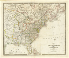
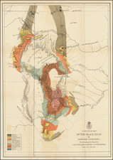
Striking full color example of Barber & Willard's rare wall map of the United States, one of the most decorative coast to coast maps of the United States published prior to 1840.
As noted by Rumsey, Barber & Willard's map is a marvelous almalgam of cartographic sources, but is perhaps most noteworthy for its striking image of the United States. Rumsey notes:
An unusual map in two sheets, showing the continent coast to coast. Tanner's influence from his North America map is evident in the west, and Long's map has influenced the plains, but Tanner's U.S. map is the primary source, in the Oregon District, the Plains, and the area east of the Mississippi. The Great Basin is filled with a table of distances and heights of mountains (which convention appears in several maps published in Hartford about this time by Thrall, Huntington, Olney's Geography, etc.). Wheat mentions the 1849 and 1850 editions of this map published by Reed and Barber, but this much earlier and different edition was unknown to him. Not in Phillips. Views of the Capital and the White House. Phelps did a related and somewhat smaller map in 1833 - see our copy. After the 1835 edition, no editions until the 1848 by Reed and Barber (see our 1849, 1850 and 1854 editions).
The map is very rare.on the market, this being the first example we have seen in about 8-10 years. The last catalogued example of the map was the 1852 edition, offered by Richard Arkway Inc. in catalog 52, item #18.
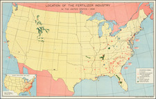
![[ Atlas - Florida and Southern Canal Projects ] Travaux d'améliorations intérieurs projetés ou exécutés par le gouvernement général des États-Unis d'Amérique, de 1824 à 1831 [complete with:] Travaux d'améliorations intérieurs projetés ou exécutés... Atlas.](https://storage.googleapis.com/raremaps/img/small/85067.jpg)