|
||

|

|
|

|
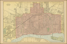
Detailed plan of the City of St. Louis, with manuscript annotations from a Civil War Officer relating to several important historical events in St. Louis during the War.
Julius Hutawa's map of St. Louis, first published in 1838, was one of the first maps of the City of St. Louis and one of the earliest printed plans of any city west of the Mississippi River. While the map went through several revised editions, our research shows that all of the editions are rare. Hutawa notes that this is the 9th edition of the map.
This example of the map, which we have dated to circa 1855 because it pre-dates the appearance of several important government installations which were built during the Civil War and because of the addition of a number of manuscript annotations in red and blue, indicating that the map was use by Major George Ernst was a member of the 15th Regiment of the Missouri Infantry, organized in St. Louis in August and September 1861, who served until January 18, 1865.
The map includes several areas shaded in blue and red which identify temporary military installments established during the Civil War. The shading was apparently the work of the original owner, a George Ernst, whose card accompanies the map along with a note from his son.
Perhaps the most famous area located (in red) is Camp Jackson, site of the so-called Camp Jackson affair. The Camp Jackson Affair was an incident of civil unrest during the Civil War, which occurred on May 10, 1861, when Union military forces clashed with civilians on the streets of St. Louis, Missouri. The highly publicized affair polarized the border state of Missouri, leading some citizens to advocate secession and others to support the Union, thus setting the stage for sustained violence between the opposing factions.
In March 1861, the Missouri Constitutional Convention of 1861 voted 98 to 1 to stay in the Union, but not supply weapons or men to either side. The security of a large munitions depot became an immediate flash point. On April 20, 1861, a pro-Confederate mob at Liberty, Missouri, seized the Liberty Arsenal (shown on the map and shaded in blue) and made off with about 1,000 rifles. This caused fear that Confederates would seize the St. Louis Arsenal, which had nearly 40,000 rifles and muskets-the most of any slave state.
Union Captain Nathaniel Lyon hastily raised a militia, gained control of the arsenal, and started sending all but 10,000 rifles to Illinois. Around May 1, Missouri Governor Claiborne Jackson, who had favored the South but was neutral, called out the Missouri Militia for "maneuvers" about 4.5 miles northwest of the arsenal at Lindell's Grove (the current campus of St. Louis University) then outside the city of St. Louis in what has been called "Camp Jackson."
Lyon sought to ascertain whether Confederate President Jefferson Davis had sent artillery (allegedly from Baton Rouge) to the camp. Legend states that Lyon visited the camp disguised as a woman. On May 10, Lyon forced the surrender of the 669 militia under General Daniel M. Frost. The men refused to take the oath of allegiance to the Federal government, so Lyon marched the prisoners through downtown St. Louis, before providing them with a parole and ordering them to disperse. This lengthy march was widely viewed as a public humiliation for the state forces, and immediately angered citizens who had gathered to watch the commotion.
Tensions quickly mounted on the streets as civilians hurled rocks, paving stones, and insults at Lyon's troops. The heavily German Home Guard units were particularly targeted by the mob. Exactly what provoked the shooting remains unclear, but the most common explanation is that a drunkard stumbled into the path of the marching soldiers, and fired a pistol into their ranks, fatally wounding one German soldier. The volunteers fired into the crowd, killing at least 20 and wounding many more.
The incident sparked several days of rioting and anti-German animosity in St. Louis. On May 11, another incident occured at the intersection of 5th and Walnut streets. Col. Henry Boernstein, publisher of the Anzeiger des Westens a prominent German Language newspaper in St. Louis and commander of the 2nd Regiment of Missouri Volunteers, remarked in his memoirs that he gave several of his men leave to visit their families on the morning of May 11 and that, "Most of them did not return…until it grew dark, with clothing torn, faces beaten bloody, and all the signs of having suffered mistreatment…Two of them never returned and they were never heard of again." Rumors spread throughout the city that the Germans were planning to murder the American population of the city which caused many of the wealthy citizens of St. Louis to flee to either Illinois or the Missouri Interior.
Eventually the installation of martial law and the arrival of Federal Regulars to relieve the German volunteers would bring the situation to a conclusion but the impact of the Camp Jackson Affair left its mark on St. Louis permanently.
The largest annotated area, shaded in blue, is Benton Barracks. War, Benton Barracks was an encampment for Union troops and was located in north St. Louis County, 4 miles from downtown St. Louis. The facility could accommodate 30,000 soldiers and contained a mile of barracks, warehouses, cavalry stables, parade grounds, and a large military hospital. The hospital itself could serve 2,000 to 3,000 patients. The Barracks was created on the lands of John O'Fallon, a descendant of O'Fallon who accompanied Lewis & Clark. Established in August 1861, the Barracks was used for a number of purposes. Perhaps most notably, during the summer of 1863, when St. Louis was inundated by thousands of refugee slaves, The Contraband (Freedman or Refugee Slave) Camp, was established at Benton Barracks, to help with the relocation. The Barracks was abandoned toward the end of the Civil War and there are very few maps which identify the Barracks.
The map is a remarkable Civil War artifact. There are a number of other annotations apparently added by Ernst in blue and red, which almost certainly reflect the relative positions of the Union and Confederate troops and sympathizers.
Other places named on the map include Jager's Garden (shaded red) and U.S. Corell (shaded blue). A number of the markings are clearly intended to denote fortified locations in and around St. Louis.
![A Map of Lewis and Clark's Track Across the Western Portion of North America, from the Mississippi to the Pacific Ocean. By Order of the Executive of the United States in 1804, 5 & 6. . . . [Complete with 3 volumes of Text: Travels to the Source of the Missouri River and Across the American Continent to the Pacific Ocean. Performed by Order of the Government of the United States, in the Years 1804, 1805, and 1806].](https://storage.googleapis.com/raremaps/img/small/81775.jpg)
![Comparative Size of Lakes and Islands [Great Lakes, Cuba, Formosa, Ireland, Sicily, Cyprus, Vancouver, Sandwich Islands, Puerto Rico, Corsica, Sardinia, Balearics, Malta, etc]](https://storage.googleapis.com/raremaps/img/small/100135.jpg)