


|
||

|

|
|

|
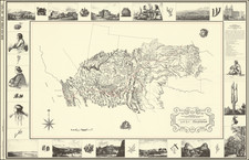
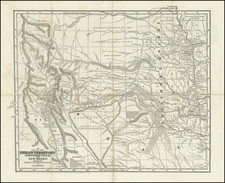
Josiah Gregg's monumental map of Northern Texas & the Plains, which accompanied his Commerce Of The Prairies, one of the classic accounts of the Transmississippi West and a cornerstone work for studies of the Santa Fe Trail.
Wheat refers to the map as a cartographic landmark and is book as the most important work on the Southwest to date. Gregg was a Santa Fe Trade. Based upon Humboldt's map of New Spain, Long's 1st Expedition and JC Brown's survey's along the Santa Fe Trail, with corrections added by Gregg from observations. Shows nearly a dozen major routes of commerce and exploration during the period. Wheat devotes 2 pages to the description of this map. An essential map for American Map collectors, illustrating an important change in the history of printed maps and the only truly American cartographic publishing innovation.
This is the example of the map which appearanced Josiah Gregg's Commerce of the Prairies. The map was also issued in Morse & Breese's Cerographic Atlas and North American Atlas, both of which are quite scarce on the market.
![[ Hungarian Traveler In the California and the West with a Comanche and Wichita to Hungarian vocabulary ] Levelei Éjszakamerikából -- Tizenkét eredeti rajzok után készült kő- és egynéhány fametszettel. Közli Prépost István (Letters from North America)](https://storage.googleapis.com/raremaps/img/small/98502.jpg)