


|
||

|

|
|

|
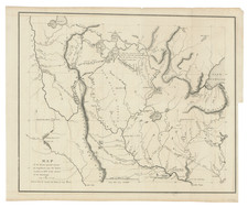
Important early map of the confluence of the three rivers, west of the Alleghany Mountains and centered on Pittsburg.
The map extends to Lake Erie and Waterford in the north and Morgantown, West Virginia, Clarksburg and Fort Cumberland in the South. The majority of detail is shown along the three rivers which form the Ohio River at Pittsburg, but there are also early roads through the Alleghany Mountains, as well as towns and details off the Rivers, including Potters Cabin on Sandy Lick Creek and Burnt Cabins near Fannetsburg in the Sideling Mountains.
The map appeared in The Journal of a Tour into the Territory Northwest of the Alleghany Mountains; made in the spring of the year 1803 . . .The book is the earliest separate historical account of Ohio. Among the sights Harris notes in his journal is the Senaca Indian Oil which oozes through fissures of the rocks and coal in the mountains and is used as a medicine for chilblains and rheumatism. This is one of the earliest references to the petroleum deposits near Pittsburgh.
The map is quite rare on the market, this being only our second example in the past 18 years, as of 2010.


![[ First Map of Pennsylvania Province ] A Map of the Province of Pensilvania Drawn from the Best Authorities By T. Kitchin Gr.](https://storage.googleapis.com/raremaps/img/small/98226.jpg)
