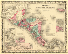
|
||

|

|
|

|
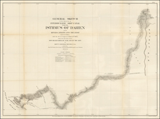
Highly detailed map showing of map the course of the proposed Panama canal which was eventually opened in 1914.
The map shows topography, the canal route, and railroads along the Panama Canal Zone. The legend locates the Center Line of Canal, Panama Railroad, Relocated Panama Railroad, Canal Zone Boundary Line, Dams, and Locks through line, color, and iconography. The width of the Canal at various points is noted, along with a host of other engineering details.
The US Congress authorized construction of a 'lock' canal in June of 1906. The United States had previously gained use of a ten mile wide "Canal Zone" in a series of negotiations and treaties, as well as purchasing the property of the French Canal Company. Drawn on June 30, 1910 in Culebra in the Canal Zone.
The Isthmian Canal Commission (often known as the ICC) was an American administration commission created to oversee the construction of the Panama Canal. Established in 1904, the ICC was given control of the Panama Canal Zone over which the United States exercised sovereignty. The commission reported directly to Secretary of War William Taft.
The ICC was initially composed of seven members, appointed by President Theodore Roosevelt, but was later reduced to three on the recommendation of John Findlay Wallace, the Chief Engineer. It was widely criticized for its perceived bureaucracy, and failure to produce any significant improvements in the early years of construction. In 1906 when a new Chief Engineer John Stevens was appointed, he wasn't a member of the Commission. He increasingly ended up bypassing the Commission and sending requests and demands straight to the Roosevelt Administration in Washington.


![[Galapagos] Carte de la Cote Occidentale D'Amerique Comprise Entre Le Golfe de Tehuantepec et le Golfe de Guayaquil (Amerique Centrale, Nlle Grenade, Equateru) . . . .1864](https://storage.googleapis.com/raremaps/img/small/57942.jpg)