|
||

|

|
|

|
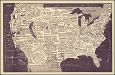
Rare Civil War edition of Wyld's fascinating map of the United States at the outset of the Civil War.
The present edition of Wyld's map includes a host of interesting details, including tables showing details regarding Free and Slave States and a reference key, identify Free States, Slaves States, Arsenals, and the Forts & Miltary Outposts of the north and south respectively. Other text boxes include additional facts about the US and its commerce, etc.
The configurations of the Western Territories are of note. Colorado is shown, Arizona is below New Mexico (Baylor Line), Texas is truncated on its western boundary and extends to the Kansas and Colorado borders (omitting the Indian Territory panhandle), with Nevada in its earliest configuraiton and Utah extending 2 degrees farther west than its final border, a line which would move eastward as anti-Mormon sentiments took hold in Washington. Oregon & Washington extend to the Rocky Mountains, with a massive Nebraska Territory to the east, extending to Canada, Minnesota, Colorado and Kansas. A very curious representation of Dacotah Territory is shown, one of the most unique representations of the Dacota.
Dakota became a Territory in March 1861 and Colorado was created as a Territory in February 1861, so it may be reasonably surmised that the map was printed in about March 1861. The reference to the Prince Consort in the credit line suggests the map was printed prior to the death of Prince Albert (the Prince Consort), in December 1861.
James Wyld was a successful and highly opportunistic publisher, who seemed to release maps based as much on marketing opportunities as the need to keep his maps current. The present map went through a number of earlier edition, while Oregon was a Territory and the Republic of Texas dominated the southwest. Remnants of the earlier edition are still visible. Wyld issued at least 1 later edition, which shows Idaho and Montana and correctly configures Utah, Arizona, New Mexico and Utah, although Texas is in the same configuration.
James Wyld Sr. (1790-1836) was a British cartographer and one of Europe’s leading mapmakers. He made many contributions to cartography, including the introduction of lithography into map printing in 1812.
William Faden, another celebrated cartographer, passed down his mapmaking business to Wyld in 1823. The quality and quantity of Faden’s maps, combined with Wyld’s considerable skill, brought Wyld great prestige.
Wyld was named geographer to Kings George IV and William IV, as well as HRH the Duke of York. In 1825, he was elected an Associate of the Institution of Civil Engineers. He was one of the founding members of the Royal Geographical Society in 1830. Also in 1830, his son, James Wyld Jr., took over his publishing house. Wyld Sr. died of overwork on October 14, 1836.
James Wyld Jr. (1812-87) was a renowned cartographer in his own right and he successfully carried on his father’s business. He gained the title of Geographer to the Queen and H.R.H. Prince Albert. Punch (1850) described him in humorous cartographic terms, “If Mr. Wyld’s brain should be ever discovered (we will be bound he has a Map of it inside his hat), we should like to have a peep at it, for we have a suspicion that the two hemispheres must be printed, varnished, and glazed, exactly like a pair of globes.”
![[Utah] Amer. Sep. No. 47. Partie Du Mexique](https://storage.googleapis.com/raremaps/img/small/88711.jpg)
![[Whoever is silent is Complicit -- Anti-Vietnam / Anti-American Poster] Vietnam: Sterminio | chi tace è complice](https://storage.googleapis.com/raremaps/img/small/89365.jpg)