|
||

|

|
|

|
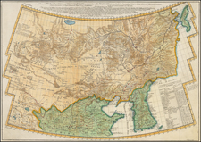
Scarce Carel Allard map of Tartary, extending from the Caspian Sea to Korea (shown properly as a peninsula).
The map is based upon Nicolas Witsen's 4-sheet map of the Russian Empire, from 1687. Witsen, the Mayor of Amsterdam, formed a powerful alliance with Czar Peter the Great of Russia at the end of the 17th Century, which was one of the cornerstone's of Russia's increasing interest in military and mapping technologies, among other things.
Carel (Carol) Allard (Allardt) (1648–1709) was an engraver and publisher based in Amsterdam. Part of a prominent family of Dutch mapmakers, publishers, and print sellers, his father was engraver and publisher Hugo Allard (1627–1684), who left his business to Carel upon his death. Carel published anything in demand, including maps, topography, ethnography, newsprints, and restrikes of old plates of artistic prints, many of which likely came from his father’s stock. In 1706, Carel gave his copperplates to his son Abraham Allard, before going bankrupt.