|
||

|

|
|

|
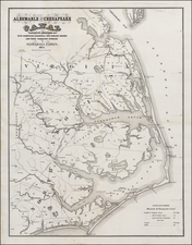
Rare example of this early map New England and New York, from Abraham Wolfgang's L'Amerique Angloise, ou Description des Isles et Terres dur Roi Angleterre, dans L'Amerique, published in Amsterdam in 1688.
The Blome-Wolfgang map of New England is a fasciinating composite of contemporary English information, compiled by Richard Blome for his Present State of His Majesties Isles and Territories in America, first published in London in 1687. As noted by Burden, the map is a unique composition, which is neither a copy of the 1672 Blome map of New England nor the 1680 Morden. Burden states, the map
. . . bears no direct resemblance to either the Blome of 1672, or the Morden which appeared in teh Blome eition of 1687. The inland waterways and Cape Cod, in particular, are very disparate. New York is shown at the tip of the Peninsula rather than being on an island, and the Hudson River bears an abrupt bend upriver.
![A Topographical Description of Such Parts of North America as are Contained in the (Annexed) Map of Middle British Colonies, &c. in North America [with map:] A Map of the Middle British Colonies in North America. First published by Mr. Lewis Evans ... in 1755; and since Corrected and Improved, as also extended with the addition of New England, and bordering parts of Canada; from actual surveys ... by T. Pownall](https://storage.googleapis.com/raremaps/img/small/100077.jpg)

![[Ascension Island] The True Description of the Island of Ascention lyeing under 8 degrees on ye South syde of ye Equinoctiall lyne.](https://storage.googleapis.com/raremaps/img/small/78964.jpg)