This item has been sold, but you can enter your email address to be notified if another example becomes available.


|
||

|

|
|

|
Stock# 23726
Description
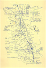
Rare early map of Eureka, California, showing subdivisions, additions, land owners, public buildings, a race course, roads, railroads and a host of other details.
This is the earliest map of Eureka, California which we could locate. The earliest map listed by OCLC was published in 1916.
The Eureka was founded in 1850. The post office opened in 1853 as the town grew, fueled by prospectors and a coming lumber boom. By 1854, there were 7 lumber mills.
Condition Description
Folding Map, with printed wraps