This item has been sold, but you can enter your email address to be notified if another example becomes available.


|
||

|

|
|

|
Stock# 23646
Description
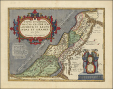
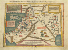
Unusual map ofthe Holy Land and Syria, from this scarce mid 19th Century British Atlas.
The map is much more detailed and includes more topographical information than most maps of the Holy Land from this period.
Fullarton's Royal Illustrated Atlas, the last highly decorative atlas published in England. Even the maps without views or figures are beautifully engraved and colored with a mixture of printed color and hand color. Swanston, Petermann, Bartholomew, Macnab and Johnson engraved the maps. The maps bear a superficial resemblance to Keith Johnston's Royal Atlas. Fullarton frequently gives the sources for his maps - for the United States maps he gives Calvin Smith and Tanner as sources.
![[ Ottoman Empire ] Carte de l'Empire des Turcs et de ses confins . . . 1664](https://storage.googleapis.com/raremaps/img/small/97055.jpg)