


|
||

|

|
|

|
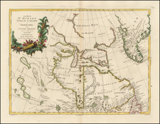
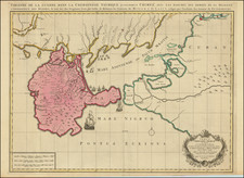
Rare 7th State of Jansson's first map of the North Polar regions, newly revised by De Wit.
This edition of the map appeared in Louis Renard's Atlas de la Navigation in 1715 and Reiner and Josua Ottens republication of the same work in 1739. Shows Baffin, Button and James Bay, Greenland, Iceland, Spitsberg (with incomplete coastline), Lappland, Russian and European Asia, etc. Numerous compass roses, sailing ships, etc. Two decorative cartouches.
The primary changes in the map, other than the title (which adds the word Novissima and De Wit's name) are that Iceland has been completely re-engraved, Nova Zemla has been completely re-engraved and the prime Meridian has been moved 10 degrees to the east. This 7th edition is apparently rare on the market, as we note no catalogued examples in dealer or auction catalogues in the past 25 years.
De Wit (1629 ca.-1706) was a mapmaker and mapseller who was born in Gouda but who worked and died in Amsterdam. He moved to the city in 1648, where he opened a printing operation under the name of The Three Crabs; later, he changed the name of his shop to The White Chart. From the 1660s onward, he published atlases with a variety of maps; he is best known for these atlases and his Dutch town maps. After Frederik’s death in 1706, his wife Maria ran the shop for four years before selling it. Their son, Franciscus, was a stockfish merchant and had no interest in the map shop. At the auction to liquidate the de Wit stock, most of the plates went to Pieter Mortier, whose firm eventually became Covens & Mortier, one of the biggest cartography houses of the eighteenth century.
![Drink Norden Kaffe [Russia]](https://storage.googleapis.com/raremaps/img/small/91603.jpg)