


|
||

|

|
|

|
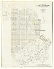
Important early map of San Francisco, the earliest obtainable map of the City.
The map shows three small sections in outline color, corresponding to the grants to Senora Briones, the claim of the heirs of Col. J.A. King, and the claim of Senor Pana under a Mexican grant. The streets, original lot numbers, government reserver, Yerba Buena Cemetery, and the earliest wharfs are shown, along with Portsmouth Square and Montgomery Fort.
The Eddy Map of San Francisco is the first City map. This Map has a title variation from the first issue of 1849, Vogdes 231, which is copyrighted by Henry Reed of New York, Drawn by Alex. Zakrzewski, and lithographed by N. Michlin. Book bound with full leather and embossed title, "Land Titles in California. Wm. Carey Jones. 1850."
William Eddy, surveyor for the town of San Francisco, created this first street map of the city in 1849. Only three years prior to the publication of the map, the United States had taken possession of that portion of California including San Francisco, and the next year, in 1847, an ordinance changed the city's name from Yerba Buena to San Francisco That same year, Jasper O'Farrell completed a survey of San Francisco covering 800 acres to Leavenworth and Fourth streets. Eddy's map extends the city limits to Larkin, Eighth, and Townsend streets. The next year, California became a state. This a wonderful early document of Gold Rush California.
![[ Death Valley - Furnace Creek Ranch ]](https://storage.googleapis.com/raremaps/img/small/98985.jpg)