|
||

|

|
|

|
Including A Fine Early Depiction of the Chesapeake
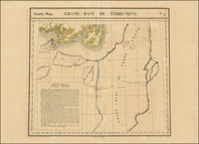
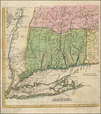
Scarce early-eighteenth century English sea chart of the East Coast of North America, which includes a second and more detailed chart of the region between Cape Henry and Long Island, one of the earliest printed maps to focus on this region.
The focus on the Chesapeake Region is a fascinating one. The map was published several years prior to the seminal Penn-Lord Baltimore Agreement, which included a map of the Chesapeake and Delaware Bay Region (also engraved by Senex), which had been the subject matter of dispute between the Penn Family and Lord Baltimore for over 40 years and which would ultimately not be finally resolved for several more decades, following the so called Chancellor's Decree of 1750 and the Mason-Dixon Survey. Created shortly after the royal proclamation in 1724 which prohibited both the Maryland and Pennsylvania Colonies from establishing new settlements in the area until a boundary had been surveyed and on the eve of Cresap's War, the focus on the region is indeed timely.
The rich Grand Banks fishing area is marked in detail, as is the Eastern seaboard of what was then the British colonies in North America. A note in the far north, where coastal detail is sparser, references the findings of a Captain Davis. John Davis (1550-1605) was a skilled navigator who worked in the service of Queen Elizabeth I and commanded several Arctic voyages in search of the Northwest Passage. The Davis Strait is named for him.
Early Mapping of Chesapeake Bay
The large-scale inset of the Chesapeake region is of particular note, being one of the most detailed chartings of the region to date. Over one hundred place names are shown, along with soundings, shoals, and other coastline geography. New Jersey and East New Jersey, written as Jarsey, are named, as are Bergen County, Essex County, Middlesex and others. The inset also includes excellent detail around New York City, Staten Island, and part of Long Island.
Chesapeake Bay was an early focus of colonial energy for Europeans, especially the Spanish, who sent early failed expeditions, and then the English. The first map to name the bay, and the first separate map of Virginia, was drawn by John White and published by Theodor de Bry in 1590. English explorer John Smith first published his iconic map of the bay and Virginia in 1612; it was reproduced in several states until the eighteenth century. Dutch charts, the best in the world in the seventeenth century, also featured detailed information about the bay, such as Johannes van Keulen’s reprint of Claes Janszoon Vooght’s Pas kaart van de zee kusten van Virginia in 1684.
Many of the maps of the seventeenth century followed Smith’s example in orienting maps of the area to the west, including, for example, Augustine Herrman’s Virginia and Maryland as it is planted and inhabited this present year 1670. Hermann’s map in turn inspired John Senex in his own maps of the area, although his were oriented to the north; Senex also worked on the atlas in which this map featured.
Atlas Maritimus et Commercialis
This chart was included in an important English maritime atlas of the early-eighteenth century, the Atlas Maritimus et Commercialis. The atlas included a geography text, sailing directions, and sea charts. It was published by, among others, the Knapton brothers, who were also responsible for some of the bestselling voyage accounts of the early- to mid-eighteenth century, including those of William Dampier.
The atlas was published specifically to rival the English Pilot, a five-volume work that was published first by John Seller, and then by his son, Jeremiah, and his partner, Charles Price, and then by Mount & Page. To differentiate it from the competition, the Atlas was published in one volume. It also featured the western and southern coasts of the Americas, which were not included in the Pilot.
Much of the text of the work is attributed to Daniel Defoe who, in addition to writing Robinson Crusoe, was also an eager advocate of colonial expansion and overseas trade. The atlas is usually attributed to John Senex, John Harris, and Henry Wilson. Nathaniel Cutler is thought to have contributed to the charts and to have written the sailing directions, which Edmund Halley supposedly edited. Edmund Halley is also mentioned on the title page as approving the projection, which most likely refers to a globular projection developed by Senex, Harris, and Wilson.
In 2015, a complete example of the atlas sold for £27,500 at Christie's in London. While the collaboration was impressive, the atlas never achieved the same commercial success. As such, the charts are quite scarce on the market.
Edmund Halley (ca. 1656-1742) was one of Britain’s foremost astronomers and natural philosophers. He was also an explorer and mapmaker famous for his voyages to study magnetic variation. Edmund was born in Shoreditch, London. After the Great Fire of 1666, his family moved to Winchester Street, near where the Royal Society, one of the world’s first scientific societies, then had its rooms.
Halley began his astronomical observations as a schoolboy at St. Paul’s School and later at Queen’s College, Oxford. By the time he left Oxford, he had already written three scientific papers and was in touch with the foremost minds in Europe, including the architect Christopher Wren, the natural philosopher Robert Hooke, and fellow astronomers, John Flamsteed, Jean Dominique Cassini, and Johann Hevelius.
Halley left Oxford without a degree because he wanted to travel to St. Helena to determine the positions of the southern stars and to observe the Transit of Mercury, a project he embarked on with the support of Charles II and the East India Company. Although not entirely successful, the star chart he published as a result earned him Fellowship in the Royal Society. In 1680, Halley and a school friend embarked on a scientific Grand Tour of Europe, observing, en route, the first appearance of a bright comet.
He discussed this comet with Isaac Newton upon his return. Halley struck up a great friendship with Newton and oversaw the publication of Newton’s masterpiece, Philosphiae naturalis principia mathematica (1687). Halley wrote the Latin preface to the work, the most important in the field of physics ever published.
In the 1680s, Halley became interested in magnetic variation. As part of these studies, he produced one of his first known maps, a chart of the trade winds, the first such meteorological chart of its kind. To gather more data on the worldwide phenomena, Halley gathered information about winds and magnetic variation from a global network and took to the sea himself to make surveys and observations. In 1689 he presented a chart of the Thames approaches to the Royal Society. In 1691, he improved the design of a diving bell to help with the salvage of a cargo of gold and ivory.
Halley’s interest in sailing and charting continued in the 1690s, even as he worked as warden to the country mint at Chester. He published a flurry of scientific papers in this decade on topics including life expectancy, optics, rainbows, thermometers, and barometers. Most influential of his work for this time, he calculated the orbit of 24 comets and concluded that comets like the one he saw while on the Grand Tour have elliptical orbits. He also explained that the comet of 1682 had a return period of roughly 75 years; this comet was later named for Halley.
In 1698, Halley was given command of the purpose-built Royal Naval ship the Paramore. He set sail for the South Atlantic to make observations of magnetic variation. He embarked on a second cruise in 1699, also to the South Atlantic. These two voyages served as the basis for a chart of magnetic variation that covered the entire Atlantic, the first surviving chart to use isogonic lines and one of the first thematic charts ever produced. In 1701, Halley took the Paramore on a final cruise in the English Channel, which resulted in another chart that was a vast improvement on previous Channel charts.
Upon outbreak of the War of Spanish Succession, Halley was charged with surveying on behalf of England, a role which took him to the Adriatic. After completing his work there, he returned to an appointment as Savilian Professor of Geometry at Oxford. One of his major projects while there was to publish Flamsteed’s star charts, a project which contributed to the already stormy relationship between the men. In 1715, Halley drew a map of totality for a rare solar eclipse that would pass through London; his observations were still being used by astronomers in the twentieth century. In 1721, he succeeded Flamsteed as the second Astronomer Royal and moved to Greenwich, where he was concerned with the saronic cycle of the moon and, as ever, comets. He died there in 1742.
![Map of the Main Portion of Pittsburg and Allegheny [with verso] Delaware. Maryland.](https://storage.googleapis.com/raremaps/img/small/84993.jpg)
![[ Virginia Indians - Priests of Secota ] Sacerdos Secotensis](https://storage.googleapis.com/raremaps/img/small/99265.jpg)
![[Nova Scotia Railway -- Shubenacadie Canal] (Hand Drawn Survey Maps)](https://storage.googleapis.com/raremaps/img/small/92802.jpg)