|
||

|

|
|

|
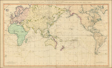
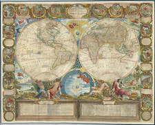
Decorative map of the world, illustrating all of the best mythical cartographic information of the mid 18th Century.
In the Northwest part of America, the Sea of the West and wonderful misprojection of the Northwest Coast of America are still shown, relying in part on the pre-Cook Russian Voyages of the 1740s. Nouvelle Holland (Australia) is still shown as attached to New Guinea and Van Diemen's land, forming a curious ephemeral shape characteristic of the mid 18th Century. Only a portion of the New Zealand Coastline is known. No sign of Antarctica, but the Antipodes are still mentioned, as is a mythical landfall by Drake South of Tierra del Fuego.
Decorated by female representations of the 4 continents in the corners of the image and decorative scenes and cartouches top and bottom. Several explorer's tracts shown. From Le Rouge's scarce Atlas Portatif… As noted by the State LIbrary of Queensland in its on line exhbition of the maps of the world,
George Louis Le Rouge was a prominent publisher in Paris from 1741 to 1789. The map shows the world in two hemispheres, with four cartouches that represent the crown, religion, conquest and trade. Geographical features include a vast Terra Incognita in North America, a misshapen Japan and New Guinea appended to Australia. Tasmania is depicted as a peninsula.
George-Louis Le Rouge (1712-1790), though known for his work in Paris, was originally born Georg Ludwig of Hanover, Germany. He grew up and was educated in Hanover, after which he became a surveyor and military engineer. Around 1740, however, Le Rouge moved to Paris and set up shop as an engraver and publisher on the Rue des Grands Augustins. It was at this time that he changed his name, adopting a French pseudonym that would later become quite famous.
Le Rouge spent much of his forty-year career translating various works from English to French, and his cartographic influence often came from English maps. His experience as a surveyor and engineer in Germany made him a skilled and prolific cartographer, and he produced thousands of charts, maps, atlases, and plans. His work spans from garden views and small-town plans to huge, multiple-continent maps. Le Rouge eventually accepted the position of Geographical Engineer for Louid XV, the King of France.
Later in life, Le Rouge became well-known for publishing North American maps, such as in his Atlas ameriquain septentrional of 1778. One of Le Rouge’s other more famous works is the Franklin/Folger chart of the Gulf Stream, which he worked on with Benjamin Franklin. Franklin and Le Rouge corresponded around 1780 and collaborated to create this map, a French version of Franklin’s famous chart which was originally printed in 1769.