This item has been sold, but you can enter your email address to be notified if another example becomes available.


|
||

|

|
|

|
Stock# 22270
Description
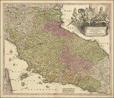
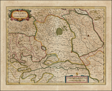
Interesting map of Italy, showing the various Italian states in the midst of the period of the Risorgimento.
Beginning with the Congress of Vienna in 1815 and the end of the Napoleonic period and ending with the Franco-Prussian War, the various states which made up Italy at the beginning of the 19th Century began to consolidate. This map shows a number of these states, including the Kingdoms of Lombardia, Venice, Sardinia and Naples, along with Parma, Modena, Toscane, and Naples.
The map appeared in a small geographical work published in Rotterdam.
Condition Description
Minor soiling and a bit of smoke damage on th very outer edges of the blank margins.
![[War pf Austrian Succession]. Theatrum Belli Sive Novissima Tabula Qua Maxima Pars Danubii Et Praeserium Hungaria Cum Aliis Adiacentibus Regnis Nec Non Graecia, Morea, et Archipelagi Insulae…](https://storage.googleapis.com/raremaps/img/small/89541.jpg)