|
||

|

|
|

|
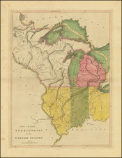
Important early territorial map of part of Minnesota Territory, depicitng the western (settled) part of Minnesota Territory, with a large inset of the full Territory (likey the second such map printed).
This map was issued the year after Minnesota became a Territory. Based largely upon the maps of Joseph N. Nicollet and John Pope, the map includes a number of annotations on early exploration and topopgraphy and records the populations of the larger settled areas, including the original Twin Cities: St. Paul and St. Anthony. Minneapolis, which later sprung up across the river from St. Anthony, is not located. The map extends east the Mississippi River and north to MIlle Lacs (Spirit Lake). Fort Gaines (Ripley) is shown, with one company of dragoons and one infantry company. The Red River Trail is shown, following the Mississippi, then crossing at Sauk Rapids and again above the confluence of the the Crow Wing or Kagiwigwan River. Ojibwe villages and trading posts are shown.
The inset map is one of the first printed maps of the full territory. As noted by Lanegran,
the map shows "a transition in the language of Minnesota's place-names from the Europeanized Dakota and Ojibwe and French names to English. The name "Mille Lacs or Spirit Lake" appears on the main map, but on the insetmap of Minnesota Territory it has been simplified to Mille Lacs. Names of the Mississippi tributaries in southeatern Minnesota are intriguing. Nearer to St. Paul, they are in English (Vermillion and Cannon), but the mre distant Zumbro River is still the Wazi Oju, and the Whitewater River is Miniskah. The Root River has two names, the Hokah or Root.
"This fascinating large scale map of part of Minnesota Territory was probably based on P.S. Morawski's much smaller scale Map of the Territory of Minnesota... published as a public document in the report of Capt. John Pope's expedition (31st. Cong. 1st. Sess. Sen Ex. Doc. 42)" - Streeter. The Streeter copy sold for $70 in 1967. In Reese's Streeter Sale Revisited (1993), the map was offered for $2,750. Reese noted only 2 locations in OCLC. There are now 3 (Yale, Wisconsin Historical Society, Library of Congress).
![Comparative Size of Lakes and Islands [Great Lakes, Cuba, Formosa, Ireland, Sicily, Cyprus, Vancouver, Sandwich Islands, Puerto Rico, Corsica, Sardinia, Balearics, Malta, etc]](https://storage.googleapis.com/raremaps/img/small/92574.jpg)
![Charte von Den Vereinigten Staaten von Nord-America nebst Louisiana . . . 1805 [Rare 1st State of Gussefeld's Louisiana Purchase Map]](https://storage.googleapis.com/raremaps/img/small/63496.jpg)