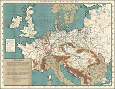
|
||

|

|
|

|
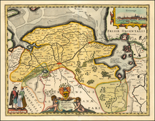
Fascinating plan depicting the remnants of Arx Britanica (also called Huis Britten, Brittenberg and Arx Britannica) Roman Castle at the mouth of the Rhine River.
Arx Britanica was fortress constructed by the Romans. The foundation of the fortress was one of the most prominent geological landmarks on the coast of Holland and could be seen at low tide at the mouth of the Middle Rhine. Legend explains that the castle was constructed at the time of the Roman Emperor Caligula, during his conquest of Britain, or by Drusus, with a later alter during the time of Claudius, who conducted an expedition to Britain. By the end of the 17th Century, "the sea had advanced sixteen hundred paces beyond it." Marsch, The Earth and Modfied by Man's Action.
Depictions of the Fortress are quite rare. Abraham Ortelius made a drawing of the building in 1567, which was copied in an engraving dated 1581. Guicciardini produced a map of Arx Britannica in 1612. Langenes also made a small map in 1649, as did Blaeu in the same year. Moll's map of the Netherlands includes a plan.
Zacharias Heyns as a map maker in Amsterdam. His works are rare. His most notably work was his edition of Ortelius' miniature atlas, Le Miroir du Monde, ou, Epitome du Theatre d'Abraham Ortelius, which included 80 maps and was published in Amsterdam.
![[Amsterdam] Amstelredamum, Nobile Inferioris Germaniae Oppidum](https://storage.googleapis.com/raremaps/img/small/96920.jpg)