


|
||

|

|
|

|
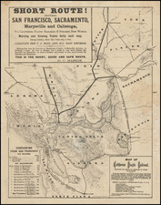
Unrecorded early California Railroad Map, one of the first printed maps to focus on the routes serviced by a single California Railroad.
The California Pacific Railroad Company was incorporated in 1865 in San Francisco as the California Pacific Rail Road Company. It was renamed the California Pacific Railroad Extension Company in the spring of 1869, then renamed the California Pacific Railroad later that same year. The railroad was constructed just months prior to the completion of the Central Pacific/Union Pacific Transcontinental Railway.
The present map is a fascinating look at the history of the California Pacific Railroad, during the brief period where it was operated by its original builder, D.C. Haskin. The map show the lines of the CPRR as they existed at some point in time between the second half of 1868 (based upon information depicted on the neighboring line between Healdsburg and Sonoma which was never in fact constructed), the time of the acquistion of the Napa Valley Rail Road Company (June 9, 1869) and the sale of the Railroad by Haskin to investors led by former California Governor and Senator Milton Slocum Latham (January 15, 1870). The Napa Valley R.R. is still shown as being a connection, rather than part of the CPRR, but the line from Davis to Sacramento is shown as completed, which did not occur until January 1870.
One of the most interesting elements of the map is the significant difference between this map and a later map of the CPRR in the collection of the University of California (Bancroft Library), dated circa 1875. The relevant portions of the two maps are shown side by side on the following link:
A comparison of the two maps shows three noteworthy differences. First, the earlier map shows a number of additional train stations, which do not appear on the later map. On 1868 map, the towns of Vaca, Batavia and Dixon are shown between Suisun and Davis's, with the town of Merritt listed north of Davis. On the 1875 Bancroft Map, Vaca, Dixon and Merritt have disappeared, as has what looks to be a spur to Vacaville. In addition, the Sutter station between Knight's Landing and Marysville is no longer shown. Second, the maps depict two very different routes for the line from the point where it separates from the Napa Valley RR and the Suisun Station. The 1868 Map shows the line veering almost due northeast toward Suisun at the town of Adelante (near the modern town of American Canyon). The 1875 Map shows the line veering to the east at a point which is several miles further north and then in a more easterly direction through a large town (Holly Oak Park) and then taking a slowly curving route toward Suisun.
Third and perhaps most notable among the differences between two maps, there are stark differences in the railroad lines shown to the west of the Napa Valley R.R. on the two maps on the lines running south out of Healdsburg. In order to fully understand the reason for the stark contrast in the two lines, a brief history of the railroad history of Sonoma County is in order. The 1868 Map and the 1875 Bancroft Map, when compared side by side, provide a remarkable graphical depiction of the activities of the competing railroad entrepreneurs active in the San Francisco Bay area immediately after the Civil War and a fascinating glimpse into the Railroad History of Sonoma County, California.
The establishment of regular railroad service in Sonoma, and specifically a line from San Francisco Bay to Healdsburg, became a significant issue in the mid 1860s. In order to spur activity, Sonoma County voters approved a subsidy of $5,000 per mile for the successful construction of the first rail line to reach Healdsburg. Over the next several years, several competitors emerged and robust if not entirely honest competition ensued.
In October 1865, C.W. Langdon of Santa Rosa, I.G. Wickersham of Petaluma, and John McMannis, of Healdsburg, organized the Petaluma & Healdsburg Railroad Company. Public opinion was divided as to what route such a railway should take. Most Sonoma County residents felt Healdsburg was a natural northern terminus, but Petaluma and Vallejo were also possibilities.
On December 26, 1867, a Petaluma investor group formed the Sonoma County Railroad Company to construct a railroad to Healdsburg, with a spur to Bloomfield (in western Sonoma County). At the same time, John Frisbie and Jackson Temple organized a rival company, which promoted a Vallejo - Sonoma- Santa Rosa route, which bypassed Petaluma completely (this is the route located on the 1868 Map which we are offering for sale). Yet another competitor, the San Francisco & Humboldt Bay Railroad Company, was incorporated on March 2, 1868, by Utah mine owner, General Patrick O'Conner. Fred McCrellish, publisher of the San Francisco Alta California, and John McCauley, a promoter and lobbyist, envisioned a route from Sausalito to Humboldt Bay (the route illustrated on the 1875 Bancroft Map).
On May 12, 1868, voters approved the bid of the Sonoma County Railroad, via Petaluma. The victors held a "ground breaking" ceremony on July 4, 1868, but no further construction occurred. The Petaluma group soon transferred their rights to the San Francisco & Humboldt Bay Railroad Company, which turned to Asbury Harpending of San Francisco for additional financing.
Harpending had been purchasing parcels for the extension of Montgomery Street across Market with banker William Ralston in 1868, when he was approached by Fred McCrellish for funding. Harpending bought out General O'Conner and John McCauley's interests, and became owner of 90% of the company. McCrellish was retained as a lobbyist for the project.
With visions of Congressional land grants through the Eel River Redwoods, Harpending began laying tracks. He sent O'Conner to Washington to lobby for the grants and even prepared plans for a suspension bridge across the Golden Gate. Grading proceeded north of Petaluma through the fall and winter of 1868, but by early 1869, Harpending was running short of cash. Harpending and Ralston held a disastrous auction of the Montgomery Street lands. Setting the minimum bid too high, the land went to shills that had been planted by the owners. A few days later construction of the railroad in Sonoma County came to a halt. Harpending reorganized as the San Francisco & North Pacific Railroad, but later sold to Peter Donahue, owner of the San Francisco & San Jose Railroad (SFNP) in June 1870.
A few days before Harpending sold his interests to Donahue, Sonoma County voters had agreed to a subsidy of $5,000 per mile to the first railroad company to complete 10 miles of track, also agreeing to issue $25,000 in bonds to the California Pacific Railroad (which had already laid 163 miles of track in northern California) upon the completion of the first 5 miles from the Napa County line. The subsidy provided that if the SFNP completed a railway through the County first, no bonds would be issued to the California Pacific.
The SFNP and California Pacific worked feverishly to meet the deadline and progress on the line continued. Regular service between Petaluma and Santa Rosa began October 31, 1870. Nevertheless, the owners of the California Pacific pressed onward. A heated race ensued, which only ended when Donahue was convinced by William Ralston, to sell out to former California Governor Milton Slocumb Latham, owner of the California Pacific. The SFNP became the Petaluma & Humboldt division of the California Pacific.
By July 1, 1871, Latham's line was open to Healdsburg. Latham in turn sold the California Pacific line to the Central Pacific in September, 1871. In a rush to complete the line and win the County subsidy by the June 21, 1872 deadline, the Central Pacific opened passenger service to Cloverdale on March 15, 1872.
Ironically, the Central Pacific soon decided that the Sonoma County line would not figure in its long range plans. In January, 1873 the line was sold back to Peter Donahue. The 1875 map depicts the line from Healdsburg to Sausalito as the SF & H RR. We have located no information suggesting that a San Francisco & Healdsburg line existed and it is possible that this is the San Francisco & Humboldt Bay Railroad, which would mean that the Bancroft's 1875 map was closer to 1869. The 1868 Map mentions to the "Sonoma Railroad" as a line in existence, suggesting that the 1868 map pre-dates the completion of a line to Healdsburg and was done at a time when it was uncertain as to which route would prevail in Sonoma County.