|
||

|

|
|

|
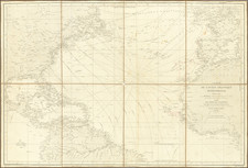
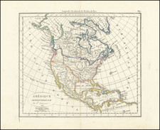
Scarce finely executed English map of North America, shown on the eve of the Seven Years War. While the title is in French, the map is very much an English production and quite rare on the market, AMPR reporting no examples offered in dealer catalogs between 1983 and 2009.
This elegantly engraved map with fine original color, demonstates the unique aesthetic quality of Jean Palairet. The map shows North America in the year before war broke out between Britain and the allied forces of France and Spain. The boundaries in the colonies were hotly contested at the time and the British victory would further scramble the status quo.
The map shows that the continent west of the Mississippi and north of Mexico was Terra Incognita to Europeans. Palairet's map is drawn directly from John Mitchell's immensely influential A Map of the British Colonies in North America, also published in 1755.. California is correctly shown to be a peninsula and the various provinces of New Spain and the islands of the Caribbean chain are all carefully labeled. The composition is completed by a magnificent title cartouche of a rococo style.
Jean Palairet was born in Montauban, France, but emigrated to England where he became a French tutor to the children of George II. He later wrote several informative books on arithmetic, language, arts and sciences, and geography. The present map is from the second edition of Palairet's greatest work, the Atlas méthodique, a magnificent cartographical demonstration, in which landmasses are shown in various stages of political definition.
As noted above, the map is quite rare, with this being the first example of the map we have offered in 15 years.
Jean Palairet (1697-1774) was a mapmaker and teacher. He was born in Montauban, France, but emigrated to England as a young man. He worked as an agent for the French States General and as the French tutor to the children of George II. Later, he served as the Agent to the Dutch States-General in London. He wrote works on orthography and French grammar, as well as published a geography primer, a teaching atlas, and his more famous map of the colonies with an accompanying pamphlet.