|
||

|

|
|

|
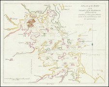
Unrecorded chart of Boston, based upon the manuscript maps taken from the voyage of Rigaudiere, at the outset of the French & Indian War. The chart extends from Nahant Bay and Charles Town to Hingam, Meneticu and Beacon Hill, and includes town illustrations of Boston, Charles Town, Dorchester, Bantrey, Milton, Meneticu and Hingam, along with several unnamed towns.
Le Rouge's chart reflects a series of detailed soundings and anchorages taken in Boston Harbor, along with an illustration of a 3 masted sailing vessel anchored off Boston. Many islands, bays, points, shoals and other harbor details are also shown.
In 1756, the French, who were keen to protect their interests in North America at the commencement of the Seven Years War, dispatched an army across the North Atlantic under the command of Louis-Joseph, Marquis de Montcalm. Among other notables who joined the cause, Louis-Antoine de Bougainville secured a position as Aide-de-camp to Montcalm. The young Bouganville sailed from Brest on the Licorne on April 3, 1756. From letters written by Bouganville, it is known that he talked extensively to the ship's captain, Chevalier de la Rigaudiere, who was apparently responsible for the manuscripts which were the source for this chart.
It is known the Rigaudiere's ship arrived in Quebec in May 1756. It is reasonable to surmise that the manuscripts maps referenced in this chart were drawn from this military voyage to America, although to date we have uncovered no records of Rigaugiere's other activities in America, except that Rigaudiere is also known to have created a plan of Louisbourg during the same period, also engraved by Le Rouge.
While Le Rouge did produce maps of Boston during the American Revolution, this is a vastly different production, which does not appear in any of the standard references on the mapping of Boston or in any American institutional collections. The map was discovered pasted to the verso of a rare (unrecorded?) plan of Cartagena (Nouveau Plan De Cartagene Avec les Derneieres Atttaques des Forts Par L'Amiral Vernon), printed in Amsterdam by Chez Vandels and based upon an English map of 1741. We cannot find any reference to this engraver or the map.
A truly extraordinary chart, providing a contemporary record of a French survey of Boston Harbor and provides anecdotal evidence of French manuscript charts of Boston Harbor prepared by a French Naval Captain at the outset of the French & Indian War. The only examples located are in the Boston Public Library, Yale and a private American collection.
George-Louis Le Rouge (1712-1790), though known for his work in Paris, was originally born Georg Ludwig of Hanover, Germany. He grew up and was educated in Hanover, after which he became a surveyor and military engineer. Around 1740, however, Le Rouge moved to Paris and set up shop as an engraver and publisher on the Rue des Grands Augustins. It was at this time that he changed his name, adopting a French pseudonym that would later become quite famous.
Le Rouge spent much of his forty-year career translating various works from English to French, and his cartographic influence often came from English maps. His experience as a surveyor and engineer in Germany made him a skilled and prolific cartographer, and he produced thousands of charts, maps, atlases, and plans. His work spans from garden views and small-town plans to huge, multiple-continent maps. Le Rouge eventually accepted the position of Geographical Engineer for Louid XV, the King of France.
Later in life, Le Rouge became well-known for publishing North American maps, such as in his Atlas ameriquain septentrional of 1778. One of Le Rouge’s other more famous works is the Franklin/Folger chart of the Gulf Stream, which he worked on with Benjamin Franklin. Franklin and Le Rouge corresponded around 1780 and collaborated to create this map, a French version of Franklin’s famous chart which was originally printed in 1769.