|
||

|

|
|

|
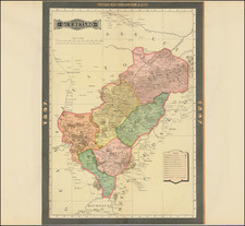
Rare map of Baja California and parts of Mexico and the area around the Gila River engraved by C. Du Puis, whom Tooley lists only a having published maps in Sonora in 1794.
The map appaeared in Beschreibung der landschaft Sonora, by Jesuit Missionary Fra. Ignaz Pfefferkorn in Cologne in 1794.
The map is a striking copper engraving, extending from the Moqui Regions of Arizona north of the Rio San Francisco and Sierra Azul, Rio Salado, Rio Assuncion and Rio Verde, along with the Colorado, and extending south to show all of Baja California and contiguous Mexico to Rio Elota. The Provinces of Ostimuri, and Sonora are shown. The map provides a remarkable depiction of the many Jesuit Missions in the interior of the Baja, including the date each mission was founded. In all, over 15 are shown, along with several presidios and other locations. The Yumas, Bajiopas, Coco-oopas, Moqui, Apaches, Papagos, Quiquimas and other early American Indian Tribes are shown on eitehr side of the Gila.
Ignaz Pfefferkorn (1726-1798) was a German born Jesuit Missionary. In 1751, he first arrived at the ruins of the Mission in Sonoyto, in Sonora (on the modern US-Mexico Border opposite Lukeville, Arizona), which had been destroyed in 1751, during an Indian uprising against the Spanish and Jesuit Missionaries. Over the next 12 years, he visited a number of Missions in the region, including the Missions of Primeria Alta. After the Jesuits fell out of favor, he returned to Spain. In 1794, he published a 3 volume work on his travels and observations in Sonora, one of the earliest comprehensive first hand accounts on the region.
![[ Southern & Central California Yokuts ] The Southern and Central Yokuts](https://storage.googleapis.com/raremaps/img/small/103201.jpg)