
![[ First Map of Hawaiian Islands ] Chart of the Sandwich Islands By James Cook](https://storage.googleapis.com/raremaps/img/small/87749.jpg)


|
||

|

|
|

|
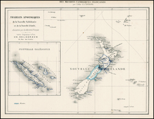
The first map of the Hawaiian Islands, from an early edition of Cook's Third Voyage.
Tracks Cooks route through the islands with dates of various observations and landfalls and provides an interesting topographical image of the islands. Large inset of Karakakooa Bay, including soundings and anchorages.
There would appear to be at least three variants of this edition of the map. All editions list the engraver as Thomas Conder and the publisher as Alexander Hogg. Two of the three editions include a circle around the the title. The third lacks the circle. Of the two editions with the circle around the title, one references Anderson's Large edition of Cook's Voyages above the top neatline, the other is blank. The edition which does not have a circle around the title also has the Anderson credit line above the top neatline.
![[ Kealakekua Bay, Hawaii ] Village de Kearakekoua. Iles Sandwich](https://storage.googleapis.com/raremaps/img/small/99764.jpg)
![Hawaii - The Aloha State [Aloha Airlines]](https://storage.googleapis.com/raremaps/img/small/86140.jpg)