|
||

|

|
|

|
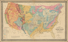
Thomas Canfield's copy of this immense unrecorded map of the United States, setting forth Canfield's earliest proposals for transportation routes from the Atlantic Ocean to the Pacific Ocean, in conjunction with his earliest promotional efforts on behalf of the Northern Pacific Railroad.
This map is provides a contemporary graphical record of one of the most fascinating and important events in the history of the expansion of the Railroad across the United States and into the American Northwest, showing the early promotional efforts and negotiations of Canfield, during his successful effort to find sponsorship for the Northern Pacific Railroad in the wake of the US Government's initial refusal to fund the development of the line.
After unsuccessfully lobbying for the right to run a railroad from the Missouri River to San Franciso, Josiah Perham received the initial charter for a railroad from Lake Superior to Puget Sound. With the help of Speaker of the House of Representatives Thaddeus Stevens of Pennsylvania, he obtained a charter in July 1864, under the name of the Northern Pacific Railroad, along with a grant of 50 million acres of land. The charter required commencement of construction by July 2, 1866.
As a result of failing health, control of the charter was later turned over to J. Gregory Smith in December, 1865. Smith made several unsuccessful attempts to obtain financing, before turning to Thomas Hawley Canfield to lead the project. Canfield successfully lobbied Congress for an extension of time to commence construction (the Union Pacific obtained a similar extension during this period), but was not able to obtain financial subsidies. As a result, he spent the rest of 1866 organizing a syndicate of twelve prominent businessmen representing other transportation interests, to gain credibility and ultimately funding for the Northern Pacific.
On January 10, 1867, Canfield obtained the agreement of the original 12 businessmen, which became known as the Original Interests Agreement. The original parties were J. Gregory Rice (Vermont Cental RR), Richard D. Rice (Maine Central RR), W.B. Ogden (Chicago & Northwestern RR), Robert H. Berdell (Erie RR), Danforth N. Barney (Wells Fargo & Co. Express Company), Ashel H. Barney (United States Express Company), Benjamin P. Cheney (United States & Canada Express Company), William G. Fargo (New York Central RR and American Express Company); George W. Cass (Pittsburg, Ft. Wayne & Chicago RR); J. Edgar Thompson (Pennsylvania RR) and Edward Reily. In 1869 Congress permitted the Northern Pacific Railroad to issue bonds under the direction of Jay Cooke and Company, and finally in 1870 ground was broken for the railroad.
Boldly signed by Canfield in the left margin, the map provides a fascinating snapshot of Canfield's work. The genesis of the map begins in 1856 with Johnson's New Illustrated & Embellished County Map of the Republics of North America, a detailed large format map published by D. Griffing Johnson. DG Johnson's map was first published by Alvin Jewett Johnson of New York and later by the J.H. Colton firm, which issued an updated edition as late as 1861. With the dissolution of the partnership between Colton and the newly formed Johnson & Browning firm in 1861, the map seems to have languished.
It can be reasonably surmised that sometime in mid-1866, Canfield approached the Colton firm, now operating as GW & CB Colton, to privately produce a large format map for Canfield's fund raising project. The uncolored map, updated to include geographical information which was current through the end of 1865, was then further embellished to include manuscript notes showing the major rail lines in the Northeastern United States (most notably, the lines operated by the members of the Original Interests Agreement) and the major water routes to the Great Lakes. The potential overland route of the Northern Pacific from Lake Superior and Lake Michigan to Puget Sound and the mouth of the Columbia River is illustrated, including annotations of distances and further illustration of the route from St. Louis up the Missouri River to a point where the river met the proposed route of the Northern Pacific. With water routes illustrated in blue and overland and rail routes in red, the finished product represents the culmination of Canfield's promotional efforts and may in fact have been intended to illustrate the Original Interests Agreement.
The map reflects Canfield and the other director's earliest vision of the route to the Pacific and tracks with his efforts to join forces with businessmen controlling alternative means of transportation, utilizing existing express, rail and other water routes as central to the proposal. More importantly, it clearly pre-dates Canfield's actual survey work in the West. The original plan was to follow the route recommended by the US Pacific Railroad Surveys of 1854, which proposed a route headed northwest from Detroit Lakes to Devil's Lake and then west. The land west of the Red River belonged to Native Americans (Sioux, Chippewa, Crow, and others). An 1867 treaty between the Government and the Indians provided that no white man should cross the Red River west for any purpose. Little was known of the area. After surveying the region, Canfield recommended a more southerly route than originally planned. He recommended going west to Yellowstone rather than north of the Missouri River as planned. Canfield's recommendation was adopted in 1870.
G. W. & C. B. Colton was a prominent family firm of mapmakers who were leaders in the American map trade in the nineteenth century. The business was founded by Joseph Hutchins Colton (1800-1893) who bought copyrights to existing maps and oversaw their production. By the 1850s, their output had expanded to include original maps, guidebooks, atlases, and railroad maps. Joseph was succeeded by his sons, George Woolworth (1827-1901) and Charles B. Colton (1831-1916). The firm was renamed G. W. & C. B. Colton as a result. George is thought responsible for their best-known work, the General Atlas, originally published under that title in 1857. In 1898, the brothers merged their business and the firm became Colton, Ohman, & Co., which operated until 1901, when August R. Ohman took on the business alone and dropped the Colton name.

![Louisiana [Large-Paper Example]](https://storage.googleapis.com/raremaps/img/small/83278.jpg)