|
||

|

|
|

|
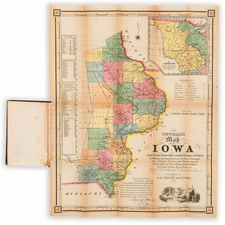
Scarce large format map of the Upper Mississippi Valley and adjacent regions, one of the most detailed and important maps of the region during the period.
The map illustrates the following areas: Carver's Grant, Sioux Cession to the U. S. , Sac and Fox Session to the U. S. , (an area) Ceded to U. S. For Indian Purposes, Cheppewas and Pottawattamies 5, 000 Acres, Sacs and Foxes 1700 Total, New Purchase, Scot's Purchase, Half Breed Tract, Quincy Land District, Alena District, Preservation of 400 Square Miles, Wisconsin District, Winnebagoes, Milwaukee District, Green Bay District, Menomonies, Agricultural Tract of the Menomonies, and N. Y. Indians.
Between 1835 and 1837, George Featherstonhaugh, a British scientist, began his journey in Washington, D.C. and traveled via Pittsburgh and Cleveland before visiting Detroit, and travelling by canoe on Lakes Huron and Michigan to Mackinac and Green Bay, thence via the Fox and Mississippi Rivers to Saint Anthony and Fort Snelling, where Featherstonhaugh's party ascended the Minnesota River as far as Lake Traverse on the Dakota border, and back again via Lake Pepin, Galena, and Saint Louis. His travels by canoe in Wisconsin and Minnesota are of particular interest.
The map is in essence the last general map of the region prior to Nicollet's map and provides an excellent visual counterpoint to Nicollet, illustrating by contrast the vast advances made by Nicollet in the region. Featherstonhaugh's map is an essential stepping stone in illustrating the evolution of the cartographic history and evolution of the Upper Mississippi Region and an essential map for regional collectors.