


|
||

|

|
|

|
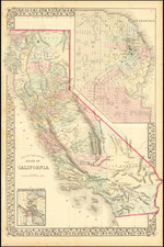
Detailed map of California, colored by county. San Bernardino, Riverside, Imperial and Orange Counties are still not shown in the South and Kings and Madera have not yet appeared, while others are not in final configurations. The map shows towns, roads, rivers, lakes, mountains, railroads, early military camps and forts and a host of other details. Large inset of San Francisco and smaller inset of SF Bay.
Normally we would offer this map for over $200.00.
Samuel Augustus Mitchell Jr. inherited the Mitchell Company from his father in 1860. For over thirty years, the company had specialized in the production of school atlases and wall maps of America. They were one of the pioneers on engraving on steel plates. In 1860, Samuel Jr. released the New General Atlas, which had been compiled in house and replaced a previous atlas by Tanner. The elder Mitchell died in 1868 and Samuel Jr. continued the business until the 1890s. At its height, the Mitchell Company employed 250 people and sold 400,000 publications annually.
![Reconnaissance of San Clemente Harbor [with] Prisoner's Harbor . . . [with] Cuyler's Harbor Island of San Miguel . . . 1852](https://storage.googleapis.com/raremaps/img/small/102987.jpg)