This item has been sold, but you can enter your email address to be notified if another example becomes available.


|
||

|

|
|

|
Stock# 18874
Description
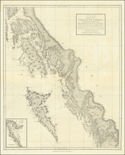
Scarce map of Alaska, Canada and the Northwestern US, in the decade following publication of Lewis & Clark's seminal map of the Northwest.
Very early appearance the 54-40 or fight Oregon Territorial boundary. Russian America appears in the Polar regions, as does a region referred to as Nouveau Cornouilles. The limits of Mackenzie, Franklin and Hearn's expeditions are noted, with dates showing the the years of exploration. Excellent detail in the Bering Straits for the period. The explorations of the Hudson's Bay Company are strongly in evidence and there is significant topographical detail throughout the region.
The first edition of the map, which would appear in Vivien St. Martin's Atlas Universel for the next decade.
![[Nome Gold Rush] Map of Seward Peninsula The Arctic Gold Fields of Alaska Showing Precinct Boundaries, Recording Offices, Post Offices, Trails & Road Houses . . . December 1903](https://storage.googleapis.com/raremaps/img/small/76156.jpg)