|
||

|

|
|

|
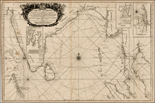
Detailed blue back chart of the South China Sea and the approches to Hong Kong and the Pearl River.
Inset maps include a large map of the Approaches to Hong Kong, Nha Trang & Bin Khang Bays, Cam Ranh Bay and Harbour, Port Xuan-Dai, Touron Bay, Cape Boung - Quioua, Yu-hin-Kan and Gaalong Bay (Hainan Island). Several coastal profiles views are also inlcuded. The map shows two proposed routes to and from Hong Kong during Fair Monsoons.
The map includes thousands of soundings and minute navigationaly details, place names, lighthouse, sailing directions, etc. One of the most detailed commercial sea charts of the period.
James Imray was a publisher specialized in nautical charts. He started one of the most successful blue-back chart-selling companies of the nineteenth century; it is still in business today. Imray’s father was a dyer and he was born in Spitalfields, London, an area known for its garment industry. James did not want to enter the garment trade, however, and instead apprenticed to Stationer William Lukyn in 1818. Imray began his business as a book publisher and seller; however, he shared premises with Robert Blachford, a chartseller. Imray entered into business with Robert’s successor, Michael. He turned the business into a success and bought Blachford out in 1846, publishing under the imprint of James Imray. In 1854, son James Frederick joined as a partner and the imprint changed to Imray & Son. They thrived thanks to targeted marketing and excellent compilation charts that focused on trade routes. The busines entered in a long decline after the death of James Sr. in 1870. In 1899, Imray & Son amalgamated with Norie & Wilson. This conglomerate was bought by the Laurie firm in 1904 and today the business trades as Imray, Laurie, Norie & Wilson.
![[Southwest Coast fo Myanmar - Myeik and Andaman Sea] Coast of Tenasserim](https://storage.googleapis.com/raremaps/img/small/64783.jpg)
![[Philippine Islands, Taiwan, etc] Partie des Isles Philippines; Partie de la Chine; Partie de L'Ile Gilolo; Partie de L'Isle Borneo](https://storage.googleapis.com/raremaps/img/small/93579.jpg)