|
||

|

|
|

|
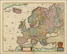
Striking large format 17th century sea chart of Western Europe.
This large scale, beautifully coloured coastal chart of Western Europe comes from
Le Neptune Francois, an important collection of charts produced by Hubert Jaillot and Pierre Mortier. As Koeman discovered in his research on this work (see P. Mortier,
Atlantes Neerlandici, Maritime Atlases, p. 423-4), Mortier re-engraved the plates after the original French prototype
Neptune Francois by Charles Pène and others in a richly colored version and added to the titles the words "Levée et Gravée par Ordre du Roy à Paris 1693", though they were in fact engraved, colored and published in Amsterdam by Mortier. The Netherlands and France were engaged in the War of the Grand Alliance at this time.
Pierre Mortier's grandparents were French refugees, who left France in about 1625 to live in Leiden. His parents settled in Amsterdam in 1661 or 1662. Pierre Mortier grew up in Amsterdam but lived in Paris from 1681 to about 1685 where he must have gotten into the book trade. Once he was in Amsterdam again he specialized in French books and maintained his relationships with Parisian publishers. Amsterdam was at this time the international marketplace for books, especially books forbidden by repressive governments. Mortier established himself in the field of cartographical publishing by offering editions of French maps, primarily Sanson's and Jaillot's to a public tired of the great but dated Dutch offerings. Working on a scale larger than the typical Dutch folio map and providing the new insights of French geography, he was immensely successful. The charts in his version of
Le Neptune Francois are outstanding examples of cartographical art. They are among the most beautiful printed sea charts ever made.
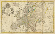
This general chart of the coast of Western Europe extends from the region west of Tronheim, Norway to about where Casablanca is on the coast of North Africa. It includes all of the British Isles and the coasts of, Denmark, northwestern Germany, Holland, France, Spain and Portugal. The map is oriented so that east is at the top of the page.
Pierre, or Pieter, Mortier (1661-1711) was a Dutch engraver, son of a French refugee. He was born in Leiden. In 1690 he was granted a privilege to publish French maps in Dutch lands. In 1693 he released the first and accompanying volume of the Neptune Francois. The third followed in 1700. His son, Cornelis (1699-1783), would partner with Johannes Covens I, creating one of the most important map publishing companies of the eighteenth century.
![Daniae Regni Typus [with] Cimbricae Chersonese nunc Iutiae descriptio ..](https://storage.googleapis.com/raremaps/img/small/94423.jpg)