|
||

|

|
|

|
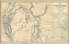
Rare early map of Oregon Territory, illustrating the indigenous Indian Tribes of the Pacific Northwest.
Eastman's map is perhaps the single best map of to illustrate the Indian Tribes of Oregon Territory, packed full of tribal names and other information. The map shows the area from the Pacific to the Rocky Mountains beyond Flathead Lake. The regions are divided and colored to indicate Indian Tribe regions. Mt. St. Helen's, Fort Nisqually, Stillicim, Mt. Rainer, Astoria and across the Columbia the settlement of Bernie's, Portland, Salem, Oregon City, and many more are named. The Olympic Peninsula is completely blank except for a range of mountains, wildly placed in a straight line down the center of the peninsula. The Emigrant Road follows the Salmon River to Fort Boise, then deviates west to join the Columbia River at Agency House.
A nice example of this fine map, from Henry Schoolcraft's Information Respecting the History, Condition and Prospects of the Indian Tribes of the United Sta tes
![Mexique par Th. Duvotenay…1842 [Republic of Texas]](https://storage.googleapis.com/raremaps/img/small/93713.jpg)
![Nouvelle Carte Du Mexique, Du Texas Et D'Une Partie Des Etats Limitrophes . . . 1840 [Proposed Railroads In Texas -- First Appearance of Arizona on a Printed Map]](https://storage.googleapis.com/raremaps/img/small/103480.jpg)
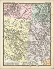
![[ Colorado Atlas -- Presentation Copy ] Geological and Geographical Atlas of Colorado and Portions of Adjacent Territory](https://storage.googleapis.com/raremaps/img/small/101702.jpg)